You are here: Home > Network List > GS - US Geological Survey Networks Stations List
> Station KAN10 Keim Farm > Earthquake Result Viewer
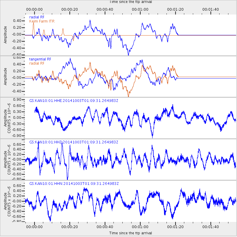
KAN10 Keim Farm - Earthquake Result Viewer
*The percent match for this event was below the threshold and hence no stack was calculated.
| Earthquake location: |
Near East Coast Of Honshu, Japan |
| Earthquake latitude/longitude: |
40.2/142.8 |
| Earthquake time(UTC): |
2014/10/03 (276) 00:57:30 GMT |
| Earthquake Depth: |
30 km |
| Earthquake Magnitude: |
5.5 MWW, 5.5 MWB, 5.6 MWC |
| Earthquake Catalog/Contributor: |
NEIC PDE/NEIC COMCAT |
|
| Network: |
GS US Geological Survey Networks |
| Station: |
KAN10 Keim Farm |
| Lat/Lon: |
37.12 N/98.10 W |
| Elevation: |
417 m |
|
| Distance: |
85.0 deg |
| Az: |
44.495 deg |
| Baz: |
317.777 deg |
| Ray Param: |
$rayparam |
*The percent match for this event was below the threshold and hence was not used in the summary stack. |
|
| Radial Match: |
53.922607 % |
| Radial Bump: |
400 |
| Transverse Match: |
34.570236 % |
| Transverse Bump: |
400 |
| SOD ConfigId: |
3390531 |
| Insert Time: |
2019-04-14 07:56:12.857 +0000 |
| GWidth: |
2.5 |
| Max Bumps: |
400 |
| Tol: |
0.001 |
|
Signal To Noise
| Channel | StoN | STA | LTA |
| GS:KAN10:01:HHZ:20141003T01:09:31.264983Z | 1.4924941 | 2.880077E-7 | 1.9297075E-7 |
| GS:KAN10:01:HHN:20141003T01:09:31.264983Z | 1.1344734 | 2.6802084E-7 | 2.3625131E-7 |
| GS:KAN10:01:HHE:20141003T01:09:31.264983Z | 1.6514835 | 4.0110743E-7 | 2.4287704E-7 |
| Arrivals |
| Ps | |
| PpPs | |
| PsPs/PpSs | |


