You are here: Home > Network List > IU - Global Seismograph Network (GSN - IRIS/USGS) Stations List
> Station RSSD Black Hills, South Dakota, USA > Earthquake Result Viewer
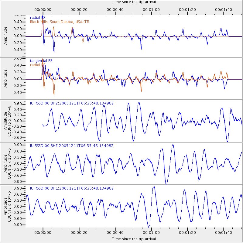
RSSD Black Hills, South Dakota, USA - Earthquake Result Viewer
*The percent match for this event was below the threshold and hence no stack was calculated.
| Earthquake location: |
Northern Mid-Atlantic Ridge |
| Earthquake latitude/longitude: |
15.3/-45.8 |
| Earthquake time(UTC): |
2005/12/11 (345) 06:26:35 GMT |
| Earthquake Depth: |
10 km |
| Earthquake Magnitude: |
5.3 MB, 5.3 MS, 5.7 MW, 5.6 MW |
| Earthquake Catalog/Contributor: |
WHDF/NEIC |
|
| Network: |
IU Global Seismograph Network (GSN - IRIS/USGS) |
| Station: |
RSSD Black Hills, South Dakota, USA |
| Lat/Lon: |
44.12 N/104.04 W |
| Elevation: |
2060 m |
|
| Distance: |
56.8 deg |
| Az: |
312.971 deg |
| Baz: |
101.326 deg |
| Ray Param: |
$rayparam |
*The percent match for this event was below the threshold and hence was not used in the summary stack. |
|
| Radial Match: |
59.664368 % |
| Radial Bump: |
400 |
| Transverse Match: |
66.32136 % |
| Transverse Bump: |
382 |
| SOD ConfigId: |
590571 |
| Insert Time: |
2013-09-25 17:52:46.242 +0000 |
| GWidth: |
2.5 |
| Max Bumps: |
400 |
| Tol: |
0.001 |
|
Signal To Noise
| Channel | StoN | STA | LTA |
| IU:RSSD:00:BHZ:20051211T06:35:48.13498Z | 1.1969445 | 3.8770776E-7 | 3.2391458E-7 |
| IU:RSSD:00:BH1:20051211T06:35:48.13498Z | 0.47985002 | 2.0223452E-7 | 4.214536E-7 |
| IU:RSSD:00:BH2:20051211T06:35:48.13498Z | 2.1030722 | 4.5490157E-7 | 2.1630336E-7 |
| Arrivals |
| Ps | |
| PpPs | |
| PsPs/PpSs | |


