You are here: Home > Network List > IU - Global Seismograph Network (GSN - IRIS/USGS) Stations List
> Station RSSD Black Hills, South Dakota, USA > Earthquake Result Viewer
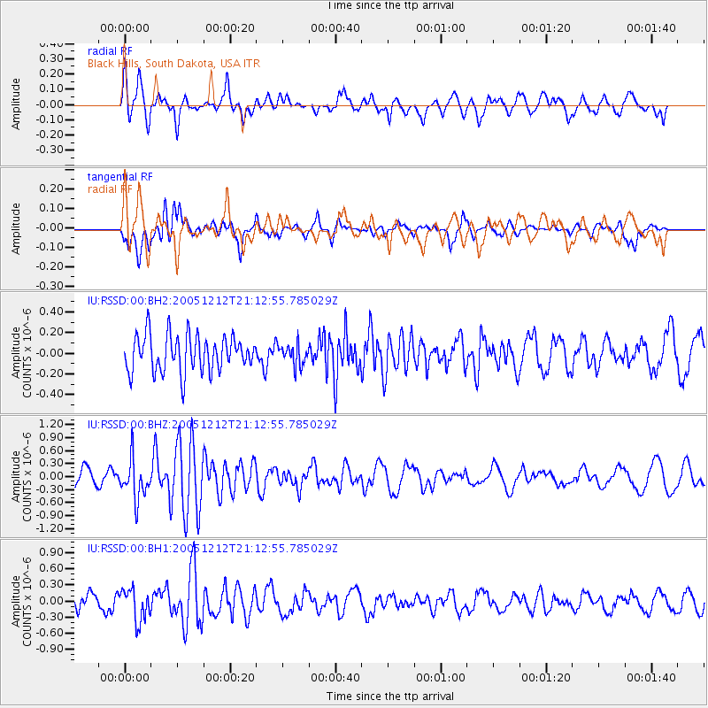
RSSD Black Hills, South Dakota, USA - Earthquake Result Viewer
*The percent match for this event was below the threshold and hence no stack was calculated.
| Earthquake location: |
Eastern Sea Of Japan |
| Earthquake latitude/longitude: |
43.2/139.3 |
| Earthquake time(UTC): |
2005/12/12 (346) 21:01:40 GMT |
| Earthquake Depth: |
26 km |
| Earthquake Magnitude: |
5.7 MB, 5.1 MS, 5.4 MW, 5.3 MW |
| Earthquake Catalog/Contributor: |
WHDF/NEIC |
|
| Network: |
IU Global Seismograph Network (GSN - IRIS/USGS) |
| Station: |
RSSD Black Hills, South Dakota, USA |
| Lat/Lon: |
44.12 N/104.04 W |
| Elevation: |
2060 m |
|
| Distance: |
76.3 deg |
| Az: |
41.506 deg |
| Baz: |
317.717 deg |
| Ray Param: |
$rayparam |
*The percent match for this event was below the threshold and hence was not used in the summary stack. |
|
| Radial Match: |
57.860146 % |
| Radial Bump: |
400 |
| Transverse Match: |
51.854706 % |
| Transverse Bump: |
400 |
| SOD ConfigId: |
590571 |
| Insert Time: |
2013-09-25 17:59:25.921 +0000 |
| GWidth: |
2.5 |
| Max Bumps: |
400 |
| Tol: |
0.001 |
|
Signal To Noise
| Channel | StoN | STA | LTA |
| IU:RSSD:00:BHZ:20051212T21:12:55.785029Z | 1.9080321 | 4.611641E-7 | 2.416962E-7 |
| IU:RSSD:00:BH1:20051212T21:12:55.785029Z | 1.6156063 | 3.0157648E-7 | 1.8666458E-7 |
| IU:RSSD:00:BH2:20051212T21:12:55.785029Z | 0.5732645 | 1.0089121E-7 | 1.7599416E-7 |
| Arrivals |
| Ps | |
| PpPs | |
| PsPs/PpSs | |


