You are here: Home > Network List > X812 - Deep Structure of Three Continental Sutures in Eastern North America Stations List
> Station QM20 Hay Lake, Maine, USA > Earthquake Result Viewer
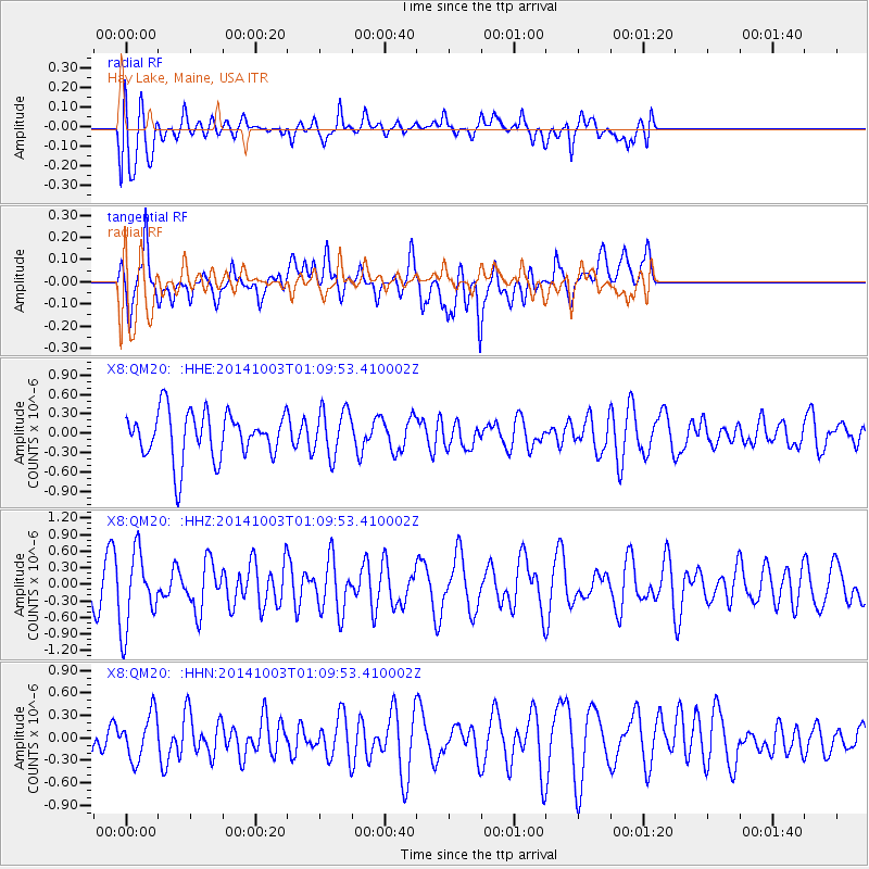
QM20 Hay Lake, Maine, USA - Earthquake Result Viewer
*The percent match for this event was below the threshold and hence no stack was calculated.
| Earthquake location: |
Near East Coast Of Honshu, Japan |
| Earthquake latitude/longitude: |
40.2/142.8 |
| Earthquake time(UTC): |
2014/10/03 (276) 00:57:30 GMT |
| Earthquake Depth: |
30 km |
| Earthquake Magnitude: |
5.5 MWW, 5.5 MWB, 5.6 MWC |
| Earthquake Catalog/Contributor: |
NEIC PDE/NEIC COMCAT |
|
| Network: |
X8 Deep Structure of Three Continental Sutures in Eastern North America |
| Station: |
QM20 Hay Lake, Maine, USA |
| Lat/Lon: |
46.13 N/68.72 W |
| Elevation: |
207 m |
|
| Distance: |
89.6 deg |
| Az: |
21.301 deg |
| Baz: |
336.402 deg |
| Ray Param: |
$rayparam |
*The percent match for this event was below the threshold and hence was not used in the summary stack. |
|
| Radial Match: |
43.504055 % |
| Radial Bump: |
400 |
| Transverse Match: |
59.736736 % |
| Transverse Bump: |
400 |
| SOD ConfigId: |
3390531 |
| Insert Time: |
2019-04-14 08:00:35.534 +0000 |
| GWidth: |
2.5 |
| Max Bumps: |
400 |
| Tol: |
0.001 |
|
Signal To Noise
| Channel | StoN | STA | LTA |
| X8:QM20: :HHZ:20141003T01:09:53.410002Z | 3.1448154 | 6.91074E-7 | 2.1975025E-7 |
| X8:QM20: :HHN:20141003T01:09:53.410002Z | 1.5600559 | 3.0529665E-7 | 1.9569599E-7 |
| X8:QM20: :HHE:20141003T01:09:53.410002Z | 0.96480566 | 3.5416846E-7 | 3.6708786E-7 |
| Arrivals |
| Ps | |
| PpPs | |
| PsPs/PpSs | |


