You are here: Home > Network List > CN - Canadian National Seismograph Network Stations List
> Station YKW2 YKW2, NT, CANADA > Earthquake Result Viewer
YKW2 YKW2, NT, CANADA - Earthquake Result Viewer

| Earthquake location: |
Samoa Islands Region |
| Earthquake latitude/longitude: |
-16.6/-172.0 |
| Earthquake time(UTC): |
2006/09/28 (271) 06:22:09 GMT |
| Earthquake Depth: |
28 km |
| Earthquake Magnitude: |
6.5 MB, 6.6 MS, 6.9 MW, 6.7 MW |
| Earthquake Catalog/Contributor: |
WHDF/NEIC |
|
| Network: |
CN Canadian National Seismograph Network |
| Station: |
YKW2 YKW2, NT, CANADA |
| Lat/Lon: |
62.43 N/114.60 W |
| Elevation: |
144 m |
|
| Distance: |
90.6 deg |
| Az: |
23.084 deg |
| Baz: |
233.913 deg |
| Ray Param: |
0.04165633 |
| Estimated Moho Depth: |
35.75 km |
| Estimated Crust Vp/Vs: |
1.84 |
| Assumed Crust Vp: |
6.459 km/s |
| Estimated Crust Vs: |
3.511 km/s |
| Estimated Crust Poisson's Ratio: |
0.29 |
|
| Radial Match: |
94.12048 % |
| Radial Bump: |
349 |
| Transverse Match: |
94.148674 % |
| Transverse Bump: |
342 |
| SOD ConfigId: |
2564 |
| Insert Time: |
2010-02-27 08:10:14.200 +0000 |
| GWidth: |
2.5 |
| Max Bumps: |
400 |
| Tol: |
0.001 |
|
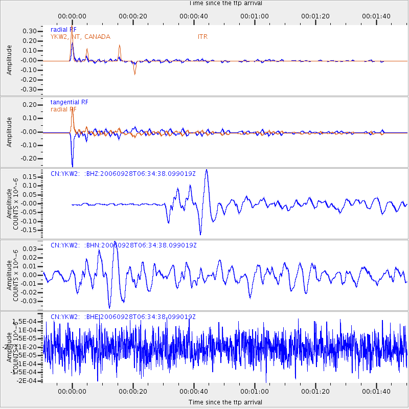
Signal To Noise
| Channel | StoN | STA | LTA |
| CN:YKW2: :BHN:20060928T06:34:38.099019Z | 4.0109634 | 1.0187014E-8 | 2.5397924E-9 |
| CN:YKW2: :BHE:20060928T06:34:38.099019Z | 1.0258266 | 6.39518E-11 | 6.234173E-11 |
| CN:YKW2: :BHZ:20060928T06:34:38.099019Z | 15.334194 | 4.837498E-8 | 3.1547127E-9 |
| Arrivals |
| Ps | 4.7 SECOND |
| PpPs | 15 SECOND |
| PsPs/PpSs | 20 SECOND |


