You are here: Home > Network List > IU - Global Seismograph Network (GSN - IRIS/USGS) Stations List
> Station RSSD Black Hills, South Dakota, USA > Earthquake Result Viewer
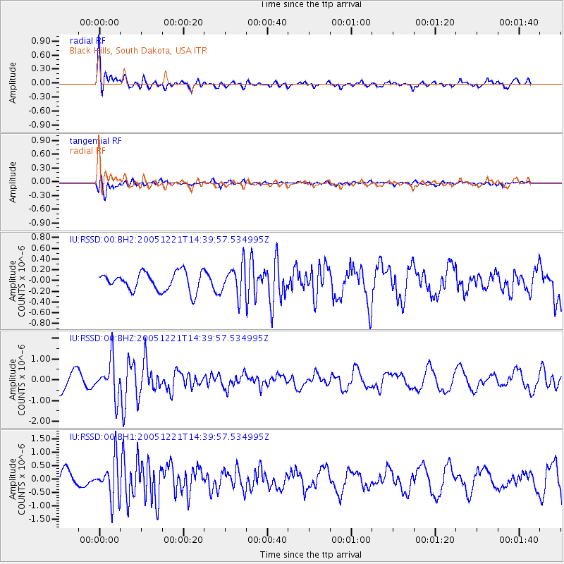
RSSD Black Hills, South Dakota, USA - Earthquake Result Viewer
*The percent match for this event was below the threshold and hence no stack was calculated.
| Earthquake location: |
South Of Panama |
| Earthquake latitude/longitude: |
6.6/-82.7 |
| Earthquake time(UTC): |
2005/12/21 (355) 14:32:39 GMT |
| Earthquake Depth: |
10 km |
| Earthquake Magnitude: |
5.9 MB, 5.3 MS, 6.0 MW, 5.8 MW |
| Earthquake Catalog/Contributor: |
WHDF/NEIC |
|
| Network: |
IU Global Seismograph Network (GSN - IRIS/USGS) |
| Station: |
RSSD Black Hills, South Dakota, USA |
| Lat/Lon: |
44.12 N/104.04 W |
| Elevation: |
2060 m |
|
| Distance: |
41.7 deg |
| Az: |
336.875 deg |
| Baz: |
147.2 deg |
| Ray Param: |
$rayparam |
*The percent match for this event was below the threshold and hence was not used in the summary stack. |
|
| Radial Match: |
68.839386 % |
| Radial Bump: |
400 |
| Transverse Match: |
56.85546 % |
| Transverse Bump: |
400 |
| SOD ConfigId: |
590571 |
| Insert Time: |
2013-09-25 18:12:45.922 +0000 |
| GWidth: |
2.5 |
| Max Bumps: |
400 |
| Tol: |
0.001 |
|
Signal To Noise
| Channel | StoN | STA | LTA |
| IU:RSSD:00:BHZ:20051221T14:39:57.534995Z | 2.0255644 | 9.009563E-7 | 4.447927E-7 |
| IU:RSSD:00:BH1:20051221T14:39:57.534995Z | 2.2969031 | 7.4456847E-7 | 3.241619E-7 |
| IU:RSSD:00:BH2:20051221T14:39:57.534995Z | 1.6487361 | 2.857142E-7 | 1.7329286E-7 |
| Arrivals |
| Ps | |
| PpPs | |
| PsPs/PpSs | |


