You are here: Home > Network List > IU - Global Seismograph Network (GSN - IRIS/USGS) Stations List
> Station RSSD Black Hills, South Dakota, USA > Earthquake Result Viewer
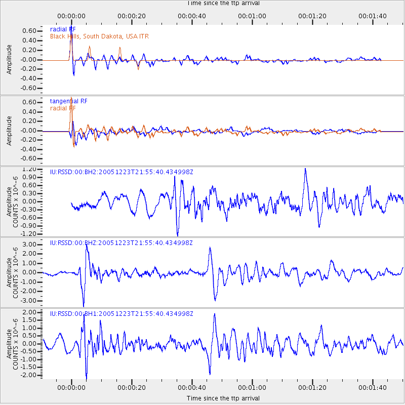
RSSD Black Hills, South Dakota, USA - Earthquake Result Viewer
*The percent match for this event was below the threshold and hence no stack was calculated.
| Earthquake location: |
Ecuador |
| Earthquake latitude/longitude: |
-1.4/-77.5 |
| Earthquake time(UTC): |
2005/12/23 (357) 21:47:28 GMT |
| Earthquake Depth: |
193 km |
| Earthquake Magnitude: |
5.8 MB, 6.1 MW, 6.1 MW |
| Earthquake Catalog/Contributor: |
WHDF/NEIC |
|
| Network: |
IU Global Seismograph Network (GSN - IRIS/USGS) |
| Station: |
RSSD Black Hills, South Dakota, USA |
| Lat/Lon: |
44.12 N/104.04 W |
| Elevation: |
2060 m |
|
| Distance: |
51.1 deg |
| Az: |
335.604 deg |
| Baz: |
145.017 deg |
| Ray Param: |
$rayparam |
*The percent match for this event was below the threshold and hence was not used in the summary stack. |
|
| Radial Match: |
77.6934 % |
| Radial Bump: |
338 |
| Transverse Match: |
50.03038 % |
| Transverse Bump: |
400 |
| SOD ConfigId: |
590571 |
| Insert Time: |
2013-09-25 18:17:25.517 +0000 |
| GWidth: |
2.5 |
| Max Bumps: |
400 |
| Tol: |
0.001 |
|
Signal To Noise
| Channel | StoN | STA | LTA |
| IU:RSSD:00:BHZ:20051223T21:55:40.434998Z | 6.290166 | 1.2054024E-6 | 1.9163286E-7 |
| IU:RSSD:00:BH1:20051223T21:55:40.434998Z | 2.6443062 | 7.349202E-7 | 2.7792555E-7 |
| IU:RSSD:00:BH2:20051223T21:55:40.434998Z | 1.4044408 | 3.131973E-7 | 2.2300497E-7 |
| Arrivals |
| Ps | |
| PpPs | |
| PsPs/PpSs | |


