You are here: Home > Network List > IU - Global Seismograph Network (GSN - IRIS/USGS) Stations List
> Station RSSD Black Hills, South Dakota, USA > Earthquake Result Viewer
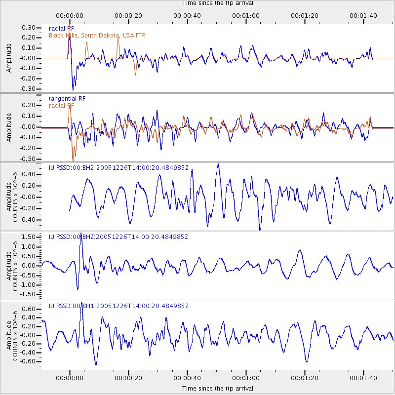
RSSD Black Hills, South Dakota, USA - Earthquake Result Viewer
*The percent match for this event was below the threshold and hence no stack was calculated.
| Earthquake location: |
Bonin Islands, Japan Region |
| Earthquake latitude/longitude: |
26.8/140.6 |
| Earthquake time(UTC): |
2005/12/26 (360) 13:48:01 GMT |
| Earthquake Depth: |
7.4 km |
| Earthquake Magnitude: |
5.8 MB, 5.3 MS, 5.7 MW, 5.5 MW |
| Earthquake Catalog/Contributor: |
WHDF/NEIC |
|
| Network: |
IU Global Seismograph Network (GSN - IRIS/USGS) |
| Station: |
RSSD Black Hills, South Dakota, USA |
| Lat/Lon: |
44.12 N/104.04 W |
| Elevation: |
2060 m |
|
| Distance: |
87.9 deg |
| Az: |
40.652 deg |
| Baz: |
306.068 deg |
| Ray Param: |
$rayparam |
*The percent match for this event was below the threshold and hence was not used in the summary stack. |
|
| Radial Match: |
62.646973 % |
| Radial Bump: |
400 |
| Transverse Match: |
51.285763 % |
| Transverse Bump: |
400 |
| SOD ConfigId: |
590571 |
| Insert Time: |
2013-09-25 18:19:14.951 +0000 |
| GWidth: |
2.5 |
| Max Bumps: |
400 |
| Tol: |
0.001 |
|
Signal To Noise
| Channel | StoN | STA | LTA |
| IU:RSSD:00:BHZ:20051226T14:00:20.484985Z | 3.424891 | 7.126915E-7 | 2.0809172E-7 |
| IU:RSSD:00:BH1:20051226T14:00:20.484985Z | 1.2441386 | 2.9441173E-7 | 2.3663901E-7 |
| IU:RSSD:00:BH2:20051226T14:00:20.484985Z | 1.0031267 | 1.9627132E-7 | 1.9565954E-7 |
| Arrivals |
| Ps | |
| PpPs | |
| PsPs/PpSs | |


