You are here: Home > Network List > CN - Canadian National Seismograph Network Stations List
> Station YKW2 YKW2, NT, CANADA > Earthquake Result Viewer
YKW2 YKW2, NT, CANADA - Earthquake Result Viewer
| Earthquake location: |
Tonga Islands |
| Earthquake latitude/longitude: |
-20.2/-174.1 |
| Earthquake time(UTC): |
2006/05/03 (123) 15:26:40 GMT |
| Earthquake Depth: |
55 km |
| Earthquake Magnitude: |
7.2 MB, 7.8 MS, 7.9 MW, 7.9 MW |
| Earthquake Catalog/Contributor: |
WHDF/NEIC |
|
| Network: |
CN Canadian National Seismograph Network |
| Station: |
YKW2 YKW2, NT, CANADA |
| Lat/Lon: |
62.43 N/114.60 W |
| Elevation: |
144 m |
|
| Distance: |
94.7 deg |
| Az: |
23.721 deg |
| Baz: |
234.315 deg |
| Ray Param: |
0.040944614 |
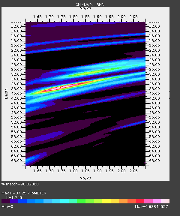
| Estimated Moho Depth: |
37.25 km |
| Estimated Crust Vp/Vs: |
1.75 |
| Assumed Crust Vp: |
6.459 km/s |
| Estimated Crust Vs: |
3.702 km/s |
| Estimated Crust Poisson's Ratio: |
0.26 |
|
| Radial Match: |
98.82868 % |
| Radial Bump: |
258 |
| Transverse Match: |
94.88907 % |
| Transverse Bump: |
400 |
| SOD ConfigId: |
2669 |
| Insert Time: |
2010-02-27 08:10:32.667 +0000 |
| GWidth: |
2.5 |
| Max Bumps: |
400 |
| Tol: |
0.001 |
|

Signal To Noise
| Channel | StoN | STA | LTA |
| CN:YKW2: :BHN:20060503T15:39:24.250022Z | 5.5195312 | 1.2176672E-8 | 2.2061062E-9 |
| CN:YKW2: :BHE:20060503T15:39:24.250022Z | 7.8957095 | 1.2215476E-8 | 1.547103E-9 |
| CN:YKW2: :BHZ:20060503T15:39:24.250022Z | 16.93015 | 5.055469E-8 | 2.9860745E-9 |
| Arrivals |
| Ps | 4.4 SECOND |
| PpPs | 16 SECOND |
| PsPs/PpSs | 20 SECOND |


