You are here: Home > Network List > CN - Canadian National Seismograph Network Stations List
> Station YKW2 YKW2, NT, CANADA > Earthquake Result Viewer
YKW2 YKW2, NT, CANADA - Earthquake Result Viewer
| Earthquake location: |
Gulf Of California |
| Earthquake latitude/longitude: |
29.0/-112.9 |
| Earthquake time(UTC): |
2009/08/03 (215) 17:59:56 GMT |
| Earthquake Depth: |
10 km |
| Earthquake Magnitude: |
6.2 MB, 6.9 MW, 6.8 MW |
| Earthquake Catalog/Contributor: |
WHDF/NEIC |
|
| Network: |
CN Canadian National Seismograph Network |
| Station: |
YKW2 YKW2, NT, CANADA |
| Lat/Lon: |
62.43 N/114.60 W |
| Elevation: |
144 m |
|
| Distance: |
33.4 deg |
| Az: |
358.563 deg |
| Baz: |
177.295 deg |
| Ray Param: |
0.07821666 |
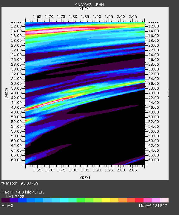
| Estimated Moho Depth: |
44.0 km |
| Estimated Crust Vp/Vs: |
1.70 |
| Assumed Crust Vp: |
6.459 km/s |
| Estimated Crust Vs: |
3.794 km/s |
| Estimated Crust Poisson's Ratio: |
0.24 |
|
| Radial Match: |
93.07759 % |
| Radial Bump: |
340 |
| Transverse Match: |
93.0776 % |
| Transverse Bump: |
340 |
| SOD ConfigId: |
2622 |
| Insert Time: |
2010-02-27 08:10:46.370 +0000 |
| GWidth: |
2.5 |
| Max Bumps: |
400 |
| Tol: |
0.001 |
|
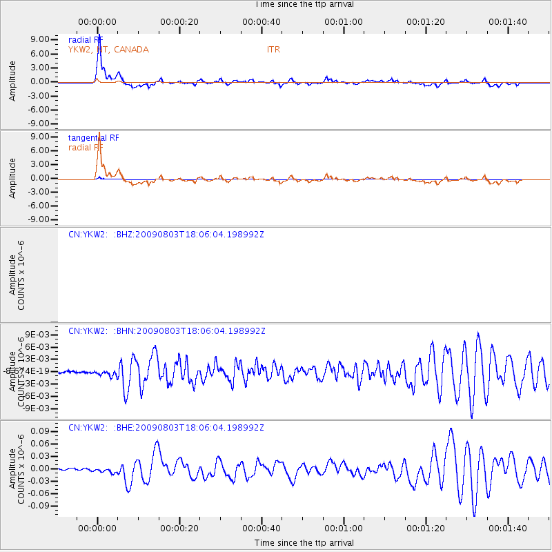
Signal To Noise
| Channel | StoN | STA | LTA |
| CN:YKW2: :BHN:20090803T18:06:04.198992Z | 2.3702157 | 7.935772E-10 | 3.3481226E-10 |
| CN:YKW2: :BHE:20090803T18:06:04.198992Z | 4.289191 | 5.680931E-9 | 1.3244761E-9 |
| $trig.getChannelId() | $trig.getValue() | $trig.getSTA() | $trig.getLTA() |
| Arrivals |
| Ps | 5.2 SECOND |
| PpPs | 17 SECOND |
| PsPs/PpSs | 22 SECOND |


