You are here: Home > Network List > CN - Canadian National Seismograph Network Stations List
> Station YKW2 YKW2, NT, CANADA > Earthquake Result Viewer
YKW2 YKW2, NT, CANADA - Earthquake Result Viewer
| Earthquake location: |
Samoa Islands Region |
| Earthquake latitude/longitude: |
-15.5/-172.1 |
| Earthquake time(UTC): |
2009/09/29 (272) 17:48:10 GMT |
| Earthquake Depth: |
18 km |
| Earthquake Magnitude: |
7.1 MB, 8.1 MS, 8.1 MW, 8.0 MW |
| Earthquake Catalog/Contributor: |
WHDF/NEIC |
|
| Network: |
CN Canadian National Seismograph Network |
| Station: |
YKW2 YKW2, NT, CANADA |
| Lat/Lon: |
62.43 N/114.60 W |
| Elevation: |
144 m |
|
| Distance: |
89.6 deg |
| Az: |
23.1 deg |
| Baz: |
234.398 deg |
| Ray Param: |
0.041728392 |
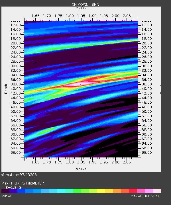
| Estimated Moho Depth: |
37.75 km |
| Estimated Crust Vp/Vs: |
1.85 |
| Assumed Crust Vp: |
6.459 km/s |
| Estimated Crust Vs: |
3.501 km/s |
| Estimated Crust Poisson's Ratio: |
0.29 |
|
| Radial Match: |
97.43398 % |
| Radial Bump: |
400 |
| Transverse Match: |
97.49662 % |
| Transverse Bump: |
400 |
| SOD ConfigId: |
2622 |
| Insert Time: |
2010-02-27 08:10:49.536 +0000 |
| GWidth: |
2.5 |
| Max Bumps: |
400 |
| Tol: |
0.001 |
|

Signal To Noise
| Channel | StoN | STA | LTA |
| CN:YKW2: :BHN:20090929T18:00:36.148997Z | 2.240363 | 1.3051135E-8 | 5.8254557E-9 |
| CN:YKW2: :BHE:20090929T18:00:36.148997Z | 2.6382349 | 3.6962176E-9 | 1.4010192E-9 |
| CN:YKW2: :BHZ:20090929T18:00:36.148997Z | 0.8745205 | 8.517225E-11 | 9.739309E-11 |
| Arrivals |
| Ps | 5.0 SECOND |
| PpPs | 16 SECOND |
| PsPs/PpSs | 21 SECOND |


