You are here: Home > Network List > IU - Global Seismograph Network (GSN - IRIS/USGS) Stations List
> Station RSSD Black Hills, South Dakota, USA > Earthquake Result Viewer
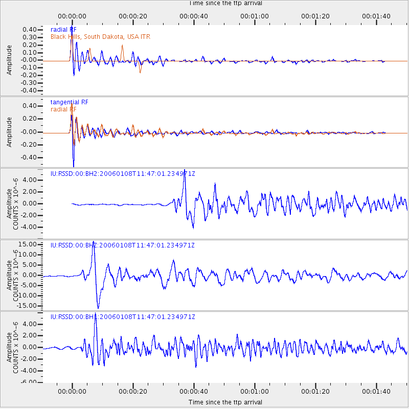
RSSD Black Hills, South Dakota, USA - Earthquake Result Viewer
*The percent match for this event was below the threshold and hence no stack was calculated.
| Earthquake location: |
Southern Greece |
| Earthquake latitude/longitude: |
36.3/23.2 |
| Earthquake time(UTC): |
2006/01/08 (008) 11:34:55 GMT |
| Earthquake Depth: |
66 km |
| Earthquake Magnitude: |
6.5 MB, 6.7 MW, 6.7 MW |
| Earthquake Catalog/Contributor: |
WHDF/NEIC |
|
| Network: |
IU Global Seismograph Network (GSN - IRIS/USGS) |
| Station: |
RSSD Black Hills, South Dakota, USA |
| Lat/Lon: |
44.12 N/104.04 W |
| Elevation: |
2060 m |
|
| Distance: |
86.7 deg |
| Az: |
324.954 deg |
| Baz: |
40.09 deg |
| Ray Param: |
$rayparam |
*The percent match for this event was below the threshold and hence was not used in the summary stack. |
|
| Radial Match: |
96.04645 % |
| Radial Bump: |
400 |
| Transverse Match: |
92.8166 % |
| Transverse Bump: |
400 |
| SOD ConfigId: |
590571 |
| Insert Time: |
2013-09-25 18:41:35.562 +0000 |
| GWidth: |
2.5 |
| Max Bumps: |
400 |
| Tol: |
0.001 |
|
Signal To Noise
| Channel | StoN | STA | LTA |
| IU:RSSD:00:BHZ:20060108T11:47:01.234971Z | 7.0166388 | 1.0710099E-6 | 1.5263859E-7 |
| IU:RSSD:00:BH1:20060108T11:47:01.234971Z | 4.1229396 | 5.592261E-7 | 1.356377E-7 |
| IU:RSSD:00:BH2:20060108T11:47:01.234971Z | 7.772813 | 4.811591E-7 | 6.1902824E-8 |
| Arrivals |
| Ps | |
| PpPs | |
| PsPs/PpSs | |


