You are here: Home > Network List > CI - Caltech Regional Seismic Network Stations List
> Station TIN Tinemaha, Big Pine, CA, USA > Earthquake Result Viewer
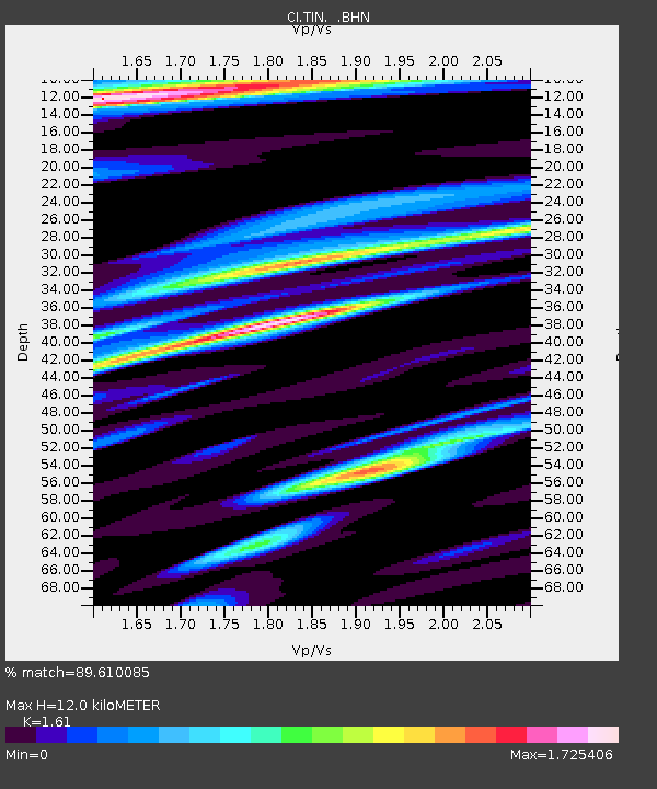
TIN Tinemaha, Big Pine, CA, USA - Earthquake Result Viewer
| Earthquake location: |
Off Coast Of Central Chile |
| Earthquake latitude/longitude: |
-28.7/-72.5 |
| Earthquake time(UTC): |
2006/07/16 (197) 11:42:41 GMT |
| Earthquake Depth: |
10 km |
| Earthquake Magnitude: |
5.9 MB, 5.7 MS, 6.2 MW, 6.2 MW |
| Earthquake Catalog/Contributor: |
WHDF/NEIC |
|
| Network: |
CI Caltech Regional Seismic Network |
| Station: |
TIN Tinemaha, Big Pine, CA, USA |
| Lat/Lon: |
37.05 N/118.23 W |
| Elevation: |
1197 m |
|
| Distance: |
78.2 deg |
| Az: |
324.215 deg |
| Baz: |
140.057 deg |
| Ray Param: |
0.04978835 |
| Estimated Moho Depth: |
12.0 km |
| Estimated Crust Vp/Vs: |
1.61 |
| Assumed Crust Vp: |
6.291 km/s |
| Estimated Crust Vs: |
3.908 km/s |
| Estimated Crust Poisson's Ratio: |
0.19 |
|
| Radial Match: |
89.610085 % |
| Radial Bump: |
400 |
| Transverse Match: |
74.12104 % |
| Transverse Bump: |
400 |
| SOD ConfigId: |
2665 |
| Insert Time: |
2010-02-25 20:44:53.628 +0000 |
| GWidth: |
2.5 |
| Max Bumps: |
400 |
| Tol: |
0.001 |
|

Signal To Noise
| Channel | StoN | STA | LTA |
| CI:TIN: :BHN:20060716T11:54:09.737026Z | 1.390859 | 4.8050657E-7 | 3.454747E-7 |
| CI:TIN: :BHE:20060716T11:54:09.737026Z | 1.6177622 | 4.4379266E-7 | 2.7432503E-7 |
| CI:TIN: :BHZ:20060716T11:54:09.737026Z | 6.191648 | 1.2700971E-6 | 2.0513069E-7 |
| Arrivals |
| Ps | 1.2 SECOND |
| PpPs | 4.8 SECOND |
| PsPs/PpSs | 6.0 SECOND |


