You are here: Home > Network List > IU - Global Seismograph Network (GSN - IRIS/USGS) Stations List
> Station POHA Pohakuloa, Hawaii, USA > Earthquake Result Viewer
POHA Pohakuloa, Hawaii, USA - Earthquake Result Viewer
*The percent match for this event was below the threshold and hence no stack was calculated.
| Earthquake location: |
Near West Coast Of Colombia |
| Earthquake latitude/longitude: |
6.8/-78.0 |
| Earthquake time(UTC): |
2006/01/23 (023) 20:52:30 GMT |
| Earthquake Depth: |
10 km |
| Earthquake Magnitude: |
5.5 MB |
| Earthquake Catalog/Contributor: |
WHDF/NEIC |
|
| Network: |
IU Global Seismograph Network (GSN - IRIS/USGS) |
| Station: |
POHA Pohakuloa, Hawaii, USA |
| Lat/Lon: |
19.76 N/155.53 W |
| Elevation: |
1967 m |
|
| Distance: |
76.0 deg |
| Az: |
288.606 deg |
| Baz: |
87.658 deg |
| Ray Param: |
$rayparam |
*The percent match for this event was below the threshold and hence was not used in the summary stack. |
|
| Radial Match: |
95.03402 % |
| Radial Bump: |
400 |
| Transverse Match: |
99.29519 % |
| Transverse Bump: |
268 |
| SOD ConfigId: |
590571 |
| Insert Time: |
2013-09-25 18:54:45.030 +0000 |
| GWidth: |
2.5 |
| Max Bumps: |
400 |
| Tol: |
0.001 |
|
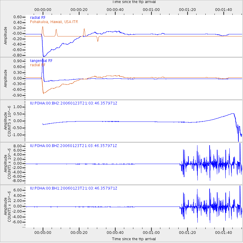
Signal To Noise
| Channel | StoN | STA | LTA |
| IU:POHA:00:BHZ:20060123T21:03:46.357971Z | 0.7106638 | 6.8288414E-10 | 9.609102E-10 |
| IU:POHA:00:BH1:20060123T21:03:46.357971Z | 0.86498034 | 7.6246975E-10 | 8.8148794E-10 |
| IU:POHA:00:BH2:20060123T21:03:46.357971Z | 0.9159339 | 6.4018806E-8 | 6.989457E-8 |
| Arrivals |
| Ps | |
| PpPs | |
| PsPs/PpSs | |


