You are here: Home > Network List > IU - Global Seismograph Network (GSN - IRIS/USGS) Stations List
> Station RSSD Black Hills, South Dakota, USA > Earthquake Result Viewer
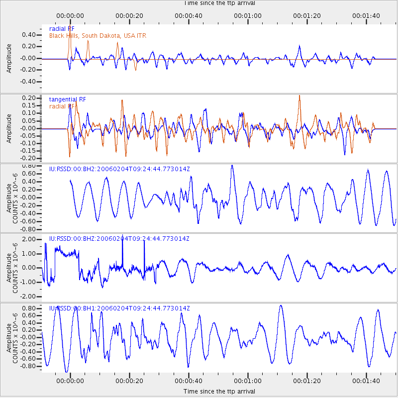
RSSD Black Hills, South Dakota, USA - Earthquake Result Viewer
*The percent match for this event was below the threshold and hence no stack was calculated.
| Earthquake location: |
Galapagos Islands Region |
| Earthquake latitude/longitude: |
1.1/-90.5 |
| Earthquake time(UTC): |
2006/02/04 (035) 09:17:04 GMT |
| Earthquake Depth: |
10 km |
| Earthquake Magnitude: |
5.4 MB, 5.4 MS, 5.9 MW, 5.9 MW |
| Earthquake Catalog/Contributor: |
WHDF/NEIC |
|
| Network: |
IU Global Seismograph Network (GSN - IRIS/USGS) |
| Station: |
RSSD Black Hills, South Dakota, USA |
| Lat/Lon: |
44.12 N/104.04 W |
| Elevation: |
2060 m |
|
| Distance: |
44.5 deg |
| Az: |
346.045 deg |
| Baz: |
160.441 deg |
| Ray Param: |
$rayparam |
*The percent match for this event was below the threshold and hence was not used in the summary stack. |
|
| Radial Match: |
40.05385 % |
| Radial Bump: |
400 |
| Transverse Match: |
44.766586 % |
| Transverse Bump: |
400 |
| SOD ConfigId: |
590571 |
| Insert Time: |
2013-09-25 19:04:54.951 +0000 |
| GWidth: |
2.5 |
| Max Bumps: |
400 |
| Tol: |
0.001 |
|
Signal To Noise
| Channel | StoN | STA | LTA |
| IU:RSSD:00:BHZ:20060204T09:24:44.773014Z | 2.6391737 | 1.056801E-6 | 4.0042872E-7 |
| IU:RSSD:00:BH1:20060204T09:24:44.773014Z | 2.1292756 | 5.7194427E-7 | 2.686098E-7 |
| IU:RSSD:00:BH2:20060204T09:24:44.773014Z | 0.28454083 | 9.238455E-8 | 3.246794E-7 |
| Arrivals |
| Ps | |
| PpPs | |
| PsPs/PpSs | |


