You are here: Home > Network List > IU - Global Seismograph Network (GSN - IRIS/USGS) Stations List
> Station RSSD Black Hills, South Dakota, USA > Earthquake Result Viewer
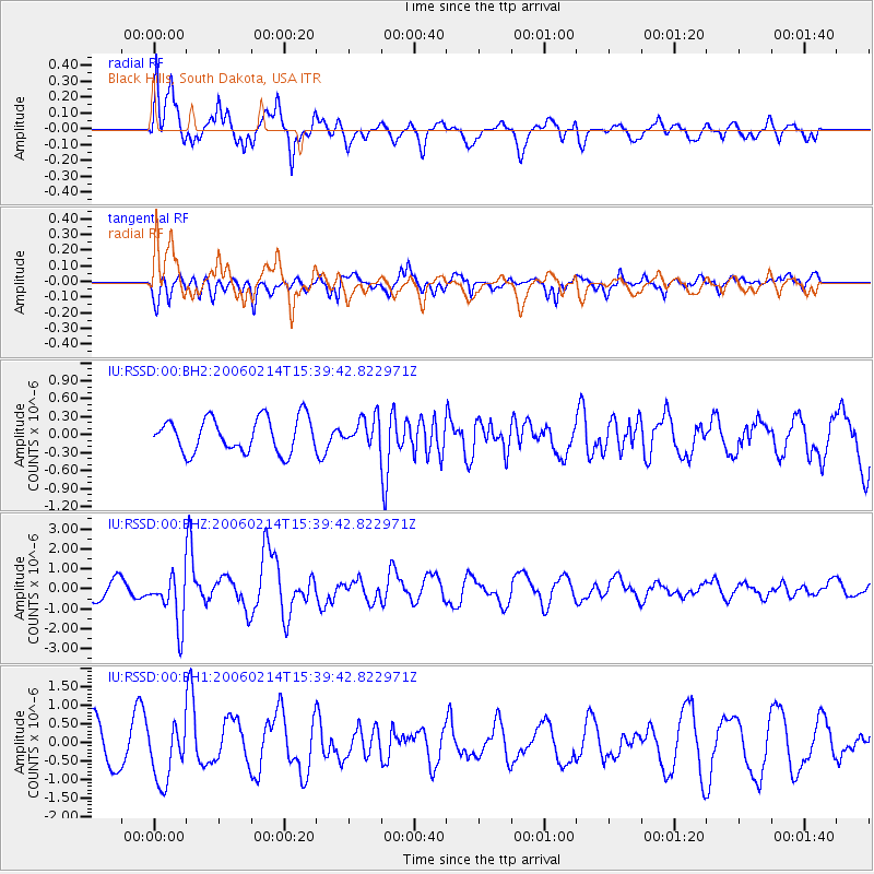
RSSD Black Hills, South Dakota, USA - Earthquake Result Viewer
*The percent match for this event was below the threshold and hence no stack was calculated.
| Earthquake location: |
Mariana Islands Region |
| Earthquake latitude/longitude: |
20.8/146.2 |
| Earthquake time(UTC): |
2006/02/14 (045) 15:27:23 GMT |
| Earthquake Depth: |
40 km |
| Earthquake Magnitude: |
6.2 MB, 6.1 MS, 6.3 MW, 6.2 MW |
| Earthquake Catalog/Contributor: |
WHDF/NEIC |
|
| Network: |
IU Global Seismograph Network (GSN - IRIS/USGS) |
| Station: |
RSSD Black Hills, South Dakota, USA |
| Lat/Lon: |
44.12 N/104.04 W |
| Elevation: |
2060 m |
|
| Distance: |
89.0 deg |
| Az: |
42.672 deg |
| Baz: |
298.31 deg |
| Ray Param: |
$rayparam |
*The percent match for this event was below the threshold and hence was not used in the summary stack. |
|
| Radial Match: |
58.825348 % |
| Radial Bump: |
387 |
| Transverse Match: |
76.41125 % |
| Transverse Bump: |
400 |
| SOD ConfigId: |
590571 |
| Insert Time: |
2013-09-25 19:11:47.976 +0000 |
| GWidth: |
2.5 |
| Max Bumps: |
400 |
| Tol: |
0.001 |
|
Signal To Noise
| Channel | StoN | STA | LTA |
| IU:RSSD:00:BHZ:20060214T15:39:42.822971Z | 2.9029346 | 1.2639571E-6 | 4.3540666E-7 |
| IU:RSSD:00:BH1:20060214T15:39:42.822971Z | 1.7278018 | 7.8437836E-7 | 4.5397474E-7 |
| IU:RSSD:00:BH2:20060214T15:39:42.822971Z | 0.80094075 | 2.2745104E-7 | 2.8397986E-7 |
| Arrivals |
| Ps | |
| PpPs | |
| PsPs/PpSs | |


