You are here: Home > Network List > IU - Global Seismograph Network (GSN - IRIS/USGS) Stations List
> Station RSSD Black Hills, South Dakota, USA > Earthquake Result Viewer
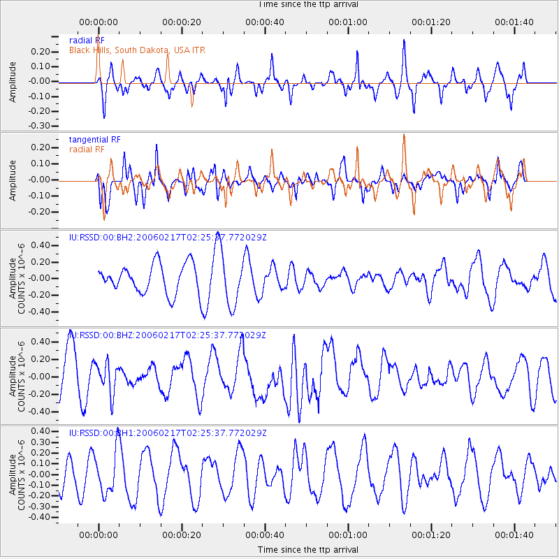
RSSD Black Hills, South Dakota, USA - Earthquake Result Viewer
*The percent match for this event was below the threshold and hence no stack was calculated.
| Earthquake location: |
Volcano Islands, Japan Region |
| Earthquake latitude/longitude: |
24.0/141.5 |
| Earthquake time(UTC): |
2006/02/17 (048) 02:13:29 GMT |
| Earthquake Depth: |
160 km |
| Earthquake Magnitude: |
5.1 MB, 5.6 MW, 5.6 MW |
| Earthquake Catalog/Contributor: |
WHDF/NEIC |
|
| Network: |
IU Global Seismograph Network (GSN - IRIS/USGS) |
| Station: |
RSSD Black Hills, South Dakota, USA |
| Lat/Lon: |
44.12 N/104.04 W |
| Elevation: |
2060 m |
|
| Distance: |
89.5 deg |
| Az: |
40.959 deg |
| Baz: |
303.667 deg |
| Ray Param: |
$rayparam |
*The percent match for this event was below the threshold and hence was not used in the summary stack. |
|
| Radial Match: |
59.558617 % |
| Radial Bump: |
317 |
| Transverse Match: |
69.62896 % |
| Transverse Bump: |
327 |
| SOD ConfigId: |
590571 |
| Insert Time: |
2013-09-25 19:13:24.237 +0000 |
| GWidth: |
2.5 |
| Max Bumps: |
400 |
| Tol: |
0.001 |
|
Signal To Noise
| Channel | StoN | STA | LTA |
| IU:RSSD:00:BHZ:20060217T02:25:37.772029Z | 0.6895256 | 1.8035296E-7 | 2.6156093E-7 |
| IU:RSSD:00:BH1:20060217T02:25:37.772029Z | 0.95039356 | 2.0254197E-7 | 2.1311378E-7 |
| IU:RSSD:00:BH2:20060217T02:25:37.772029Z | 1.7909458 | 3.102975E-7 | 1.7325901E-7 |
| Arrivals |
| Ps | |
| PpPs | |
| PsPs/PpSs | |


