You are here: Home > Network List > IU - Global Seismograph Network (GSN - IRIS/USGS) Stations List
> Station POHA Pohakuloa, Hawaii, USA > Earthquake Result Viewer
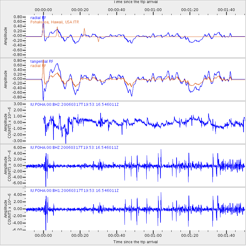
POHA Pohakuloa, Hawaii, USA - Earthquake Result Viewer
*The percent match for this event was below the threshold and hence no stack was calculated.
| Earthquake location: |
Tonga Islands |
| Earthquake latitude/longitude: |
-15.3/-175.7 |
| Earthquake time(UTC): |
2006/03/17 (076) 19:46:11 GMT |
| Earthquake Depth: |
10 km |
| Earthquake Magnitude: |
5.6 MW, 5.3 MS, 5.2 MB, 5.6 MW |
| Earthquake Catalog/Contributor: |
WHDF/NEIC |
|
| Network: |
IU Global Seismograph Network (GSN - IRIS/USGS) |
| Station: |
POHA Pohakuloa, Hawaii, USA |
| Lat/Lon: |
19.76 N/155.53 W |
| Elevation: |
1967 m |
|
| Distance: |
40.1 deg |
| Az: |
30.306 deg |
| Baz: |
211.129 deg |
| Ray Param: |
$rayparam |
*The percent match for this event was below the threshold and hence was not used in the summary stack. |
|
| Radial Match: |
54.28345 % |
| Radial Bump: |
400 |
| Transverse Match: |
35.56817 % |
| Transverse Bump: |
400 |
| SOD ConfigId: |
590571 |
| Insert Time: |
2013-09-25 19:45:27.335 +0000 |
| GWidth: |
2.5 |
| Max Bumps: |
400 |
| Tol: |
0.001 |
|
Signal To Noise
| Channel | StoN | STA | LTA |
| IU:POHA:00:BHZ:20060317T19:53:16.546011Z | 2.3157504 | 1.4198675E-6 | 6.13135E-7 |
| IU:POHA:00:BH1:20060317T19:53:16.546011Z | 2.2236524 | 1.2129424E-6 | 5.4547303E-7 |
| IU:POHA:00:BH2:20060317T19:53:16.546011Z | 0.4672593 | 3.9070937E-7 | 8.3617255E-7 |
| Arrivals |
| Ps | |
| PpPs | |
| PsPs/PpSs | |


