You are here: Home > Network List > IU - Global Seismograph Network (GSN - IRIS/USGS) Stations List
> Station RSSD Black Hills, South Dakota, USA > Earthquake Result Viewer
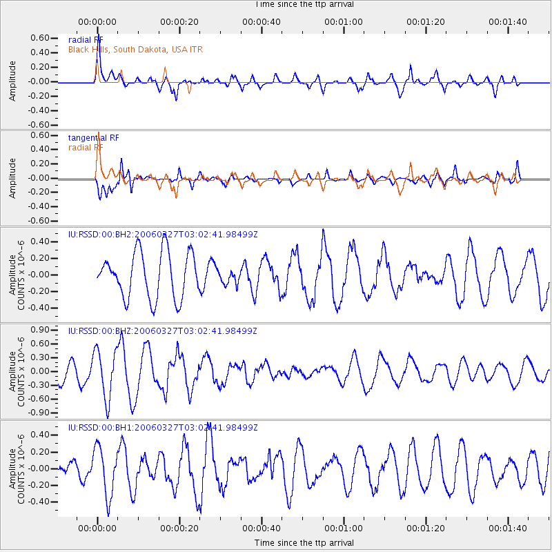
RSSD Black Hills, South Dakota, USA - Earthquake Result Viewer
*The percent match for this event was below the threshold and hence no stack was calculated.
| Earthquake location: |
Shikoku, Japan |
| Earthquake latitude/longitude: |
32.6/132.2 |
| Earthquake time(UTC): |
2006/03/27 (086) 02:50:26 GMT |
| Earthquake Depth: |
35 km |
| Earthquake Magnitude: |
5.7 MS, 5.5 MW, 5.5 MW |
| Earthquake Catalog/Contributor: |
NEIC PDE/NEIC PDE-M |
|
| Network: |
IU Global Seismograph Network (GSN - IRIS/USGS) |
| Station: |
RSSD Black Hills, South Dakota, USA |
| Lat/Lon: |
44.12 N/104.04 W |
| Elevation: |
2060 m |
|
| Distance: |
88.1 deg |
| Az: |
36.782 deg |
| Baz: |
315.432 deg |
| Ray Param: |
$rayparam |
*The percent match for this event was below the threshold and hence was not used in the summary stack. |
|
| Radial Match: |
72.02621 % |
| Radial Bump: |
400 |
| Transverse Match: |
83.766174 % |
| Transverse Bump: |
400 |
| SOD ConfigId: |
590571 |
| Insert Time: |
2013-09-25 19:55:38.313 +0000 |
| GWidth: |
2.5 |
| Max Bumps: |
400 |
| Tol: |
0.001 |
|
Signal To Noise
| Channel | StoN | STA | LTA |
| IU:RSSD:00:BHZ:20060327T03:02:41.98499Z | 1.889391 | 5.438091E-7 | 2.8782242E-7 |
| IU:RSSD:00:BH1:20060327T03:02:41.98499Z | 1.4262905 | 2.9674004E-7 | 2.0805021E-7 |
| IU:RSSD:00:BH2:20060327T03:02:41.98499Z | 0.3132661 | 8.6136666E-8 | 2.7496327E-7 |
| Arrivals |
| Ps | |
| PpPs | |
| PsPs/PpSs | |


