You are here: Home > Network List > IU - Global Seismograph Network (GSN - IRIS/USGS) Stations List
> Station RSSD Black Hills, South Dakota, USA > Earthquake Result Viewer
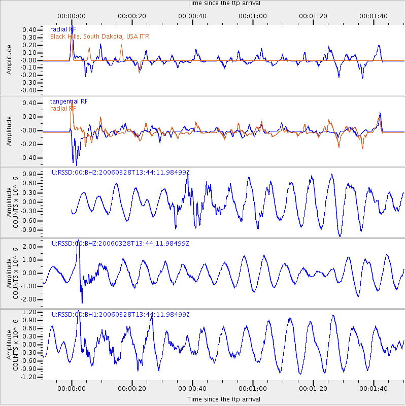
RSSD Black Hills, South Dakota, USA - Earthquake Result Viewer
*The percent match for this event was below the threshold and hence no stack was calculated.
| Earthquake location: |
Southeast Of Honshu, Japan |
| Earthquake latitude/longitude: |
31.7/137.7 |
| Earthquake time(UTC): |
2006/03/28 (087) 13:32:47 GMT |
| Earthquake Depth: |
401 km |
| Earthquake Magnitude: |
5.5 MB, 5.9 MW, 5.9 MW |
| Earthquake Catalog/Contributor: |
WHDF/NEIC |
|
| Network: |
IU Global Seismograph Network (GSN - IRIS/USGS) |
| Station: |
RSSD Black Hills, South Dakota, USA |
| Lat/Lon: |
44.12 N/104.04 W |
| Elevation: |
2060 m |
|
| Distance: |
85.8 deg |
| Az: |
39.517 deg |
| Baz: |
311.152 deg |
| Ray Param: |
$rayparam |
*The percent match for this event was below the threshold and hence was not used in the summary stack. |
|
| Radial Match: |
73.78989 % |
| Radial Bump: |
400 |
| Transverse Match: |
87.46293 % |
| Transverse Bump: |
400 |
| SOD ConfigId: |
590571 |
| Insert Time: |
2013-09-25 19:58:31.946 +0000 |
| GWidth: |
2.5 |
| Max Bumps: |
400 |
| Tol: |
0.001 |
|
Signal To Noise
| Channel | StoN | STA | LTA |
| IU:RSSD:00:BHZ:20060328T13:44:11.98499Z | 2.9873993 | 1.1899273E-6 | 3.9831542E-7 |
| IU:RSSD:00:BH1:20060328T13:44:11.98499Z | 1.1353463 | 5.8901617E-7 | 5.187987E-7 |
| IU:RSSD:00:BH2:20060328T13:44:11.98499Z | 1.245332 | 3.6600002E-7 | 2.9389756E-7 |
| Arrivals |
| Ps | |
| PpPs | |
| PsPs/PpSs | |


