You are here: Home > Network List > IU - Global Seismograph Network (GSN - IRIS/USGS) Stations List
> Station PMG Port Moresby, New Guinea > Earthquake Result Viewer
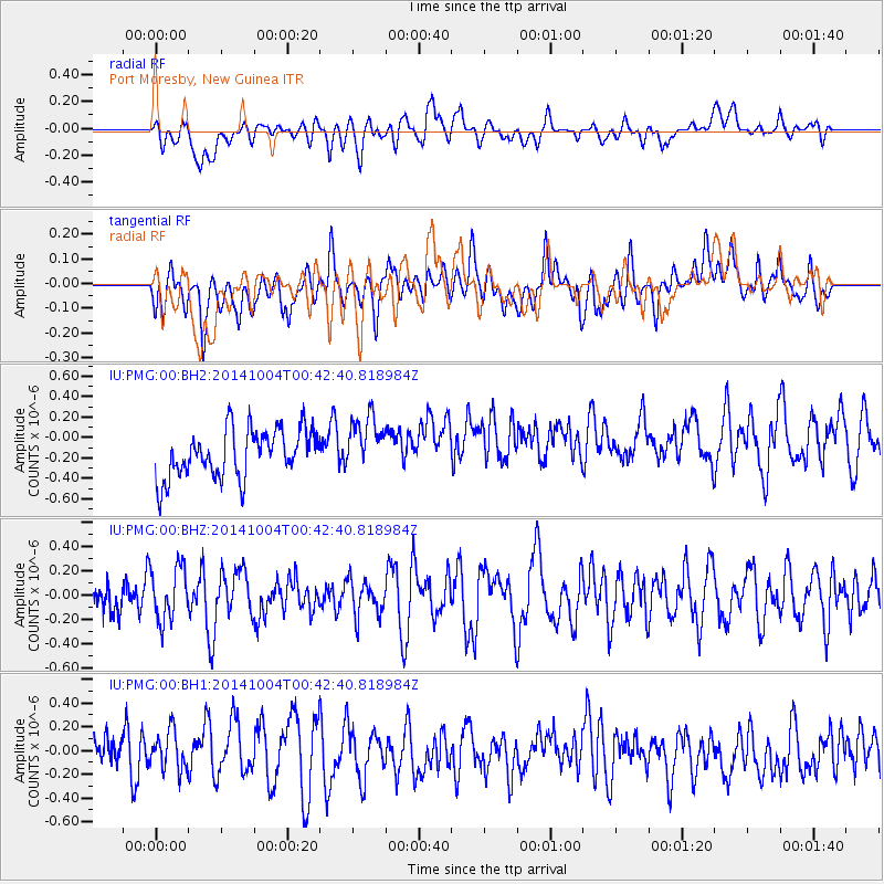
PMG Port Moresby, New Guinea - Earthquake Result Viewer
*The percent match for this event was below the threshold and hence no stack was calculated.
| Earthquake location: |
Kuril Islands |
| Earthquake latitude/longitude: |
44.5/148.0 |
| Earthquake time(UTC): |
2014/10/04 (277) 00:33:59 GMT |
| Earthquake Depth: |
99 km |
| Earthquake Magnitude: |
4.9 MW |
| Earthquake Catalog/Contributor: |
ISC/ISC |
|
| Network: |
IU Global Seismograph Network (GSN - IRIS/USGS) |
| Station: |
PMG Port Moresby, New Guinea |
| Lat/Lon: |
9.40 S/147.16 E |
| Elevation: |
90 m |
|
| Distance: |
53.7 deg |
| Az: |
181.038 deg |
| Baz: |
0.753 deg |
| Ray Param: |
$rayparam |
*The percent match for this event was below the threshold and hence was not used in the summary stack. |
|
| Radial Match: |
38.343807 % |
| Radial Bump: |
400 |
| Transverse Match: |
43.27619 % |
| Transverse Bump: |
400 |
| SOD ConfigId: |
3390531 |
| Insert Time: |
2019-04-14 08:27:01.429 +0000 |
| GWidth: |
2.5 |
| Max Bumps: |
400 |
| Tol: |
0.001 |
|
Signal To Noise
| Channel | StoN | STA | LTA |
| IU:PMG:00:BHZ:20141004T00:42:40.818984Z | 0.9836194 | 2.2124868E-7 | 2.2493323E-7 |
| IU:PMG:00:BH1:20141004T00:42:40.818984Z | 0.5053107 | 1.8021119E-7 | 3.566344E-7 |
| IU:PMG:00:BH2:20141004T00:42:40.818984Z | 1.1580325 | 2.6971577E-7 | 2.3290863E-7 |
| Arrivals |
| Ps | |
| PpPs | |
| PsPs/PpSs | |


