You are here: Home > Network List > IU - Global Seismograph Network (GSN - IRIS/USGS) Stations List
> Station RSSD Black Hills, South Dakota, USA > Earthquake Result Viewer
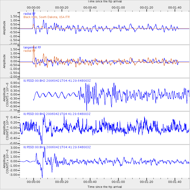
RSSD Black Hills, South Dakota, USA - Earthquake Result Viewer
*The percent match for this event was below the threshold and hence no stack was calculated.
| Earthquake location: |
Eastern Siberia, Russia |
| Earthquake latitude/longitude: |
60.5/165.8 |
| Earthquake time(UTC): |
2006/04/21 (111) 04:32:43 GMT |
| Earthquake Depth: |
9.0 km |
| Earthquake Magnitude: |
6.3 MB, 5.6 MS, 6.1 MW, 6.1 ME |
| Earthquake Catalog/Contributor: |
WHDF/NEIC |
|
| Network: |
IU Global Seismograph Network (GSN - IRIS/USGS) |
| Station: |
RSSD Black Hills, South Dakota, USA |
| Lat/Lon: |
44.12 N/104.04 W |
| Elevation: |
2060 m |
|
| Distance: |
53.0 deg |
| Az: |
64.424 deg |
| Baz: |
321.731 deg |
| Ray Param: |
$rayparam |
*The percent match for this event was below the threshold and hence was not used in the summary stack. |
|
| Radial Match: |
50.137424 % |
| Radial Bump: |
400 |
| Transverse Match: |
57.679157 % |
| Transverse Bump: |
400 |
| SOD ConfigId: |
590571 |
| Insert Time: |
2013-09-25 20:31:08.988 +0000 |
| GWidth: |
2.5 |
| Max Bumps: |
400 |
| Tol: |
0.001 |
|
Signal To Noise
| Channel | StoN | STA | LTA |
| IU:RSSD:00:BHZ:20060421T04:41:29.648003Z | 0.81098115 | 1.5315935E-7 | 1.8885684E-7 |
| IU:RSSD:00:BH1:20060421T04:41:29.648003Z | 4.661626 | 6.327652E-7 | 1.3573917E-7 |
| IU:RSSD:00:BH2:20060421T04:41:29.648003Z | 1.387556 | 2.0392966E-7 | 1.469704E-7 |
| Arrivals |
| Ps | |
| PpPs | |
| PsPs/PpSs | |


