You are here: Home > Network List > IU - Global Seismograph Network (GSN - IRIS/USGS) Stations List
> Station RSSD Black Hills, South Dakota, USA > Earthquake Result Viewer
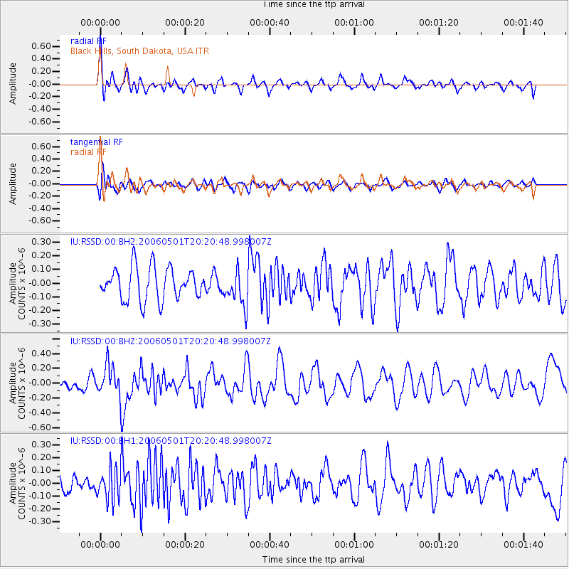
RSSD Black Hills, South Dakota, USA - Earthquake Result Viewer
*The percent match for this event was below the threshold and hence no stack was calculated.
| Earthquake location: |
West Of Galapagos Islands |
| Earthquake latitude/longitude: |
2.2/-99.0 |
| Earthquake time(UTC): |
2006/05/01 (121) 20:13:28 GMT |
| Earthquake Depth: |
10 km |
| Earthquake Magnitude: |
5.7 MW, 5.0 MB, 5.7 MW |
| Earthquake Catalog/Contributor: |
WHDF/NEIC |
|
| Network: |
IU Global Seismograph Network (GSN - IRIS/USGS) |
| Station: |
RSSD Black Hills, South Dakota, USA |
| Lat/Lon: |
44.12 N/104.04 W |
| Elevation: |
2060 m |
|
| Distance: |
42.0 deg |
| Az: |
354.613 deg |
| Baz: |
172.516 deg |
| Ray Param: |
$rayparam |
*The percent match for this event was below the threshold and hence was not used in the summary stack. |
|
| Radial Match: |
67.05107 % |
| Radial Bump: |
400 |
| Transverse Match: |
57.67219 % |
| Transverse Bump: |
400 |
| SOD ConfigId: |
590571 |
| Insert Time: |
2013-09-25 20:59:55.782 +0000 |
| GWidth: |
2.5 |
| Max Bumps: |
400 |
| Tol: |
0.001 |
|
Signal To Noise
| Channel | StoN | STA | LTA |
| IU:RSSD:00:BHZ:20060501T20:20:48.998007Z | 3.0048265 | 2.0679111E-7 | 6.881965E-8 |
| IU:RSSD:00:BH1:20060501T20:20:48.998007Z | 1.6755576 | 1.2440042E-7 | 7.4244184E-8 |
| IU:RSSD:00:BH2:20060501T20:20:48.998007Z | 1.1079818 | 1.3031692E-7 | 1.1761648E-7 |
| Arrivals |
| Ps | |
| PpPs | |
| PsPs/PpSs | |


