You are here: Home > Network List > TA - USArray Transportable Network (new EarthScope stations) Stations List
> Station D62A Allapoint, Allagash, ME, USA > Earthquake Result Viewer
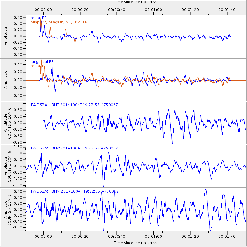
D62A Allapoint, Allagash, ME, USA - Earthquake Result Viewer
*The percent match for this event was below the threshold and hence no stack was calculated.
| Earthquake location: |
Chiapas, Mexico |
| Earthquake latitude/longitude: |
17.4/-94.9 |
| Earthquake time(UTC): |
2014/10/04 (277) 19:16:36 GMT |
| Earthquake Depth: |
143 km |
| Earthquake Magnitude: |
5.6 MWW, 5.5 MWB, 5.7 MWC |
| Earthquake Catalog/Contributor: |
NEIC PDE/NEIC COMCAT |
|
| Network: |
TA USArray Transportable Network (new EarthScope stations) |
| Station: |
D62A Allapoint, Allagash, ME, USA |
| Lat/Lon: |
47.08 N/69.05 W |
| Elevation: |
189 m |
|
| Distance: |
36.5 deg |
| Az: |
30.064 deg |
| Baz: |
224.422 deg |
| Ray Param: |
$rayparam |
*The percent match for this event was below the threshold and hence was not used in the summary stack. |
|
| Radial Match: |
67.14374 % |
| Radial Bump: |
388 |
| Transverse Match: |
68.102264 % |
| Transverse Bump: |
377 |
| SOD ConfigId: |
3390531 |
| Insert Time: |
2019-04-14 08:43:37.210 +0000 |
| GWidth: |
2.5 |
| Max Bumps: |
400 |
| Tol: |
0.001 |
|
Signal To Noise
| Channel | StoN | STA | LTA |
| TA:D62A: :BHZ:20141004T19:22:55.475006Z | 2.409183 | 3.5224463E-7 | 1.4620916E-7 |
| TA:D62A: :BHN:20141004T19:22:55.475006Z | 1.2584116 | 2.222546E-7 | 1.7661519E-7 |
| TA:D62A: :BHE:20141004T19:22:55.475006Z | 1.5595646 | 2.713758E-7 | 1.7400743E-7 |
| Arrivals |
| Ps | |
| PpPs | |
| PsPs/PpSs | |


