You are here: Home > Network List > CN - Canadian National Seismograph Network Stations List
> Station YKW3 YKW3, NT, CANADA > Earthquake Result Viewer
YKW3 YKW3, NT, CANADA - Earthquake Result Viewer

| Earthquake location: |
Near Coast Of Chiapas, Mexico |
| Earthquake latitude/longitude: |
15.6/-93.1 |
| Earthquake time(UTC): |
2001/11/28 (332) 14:32:32 GMT |
| Earthquake Depth: |
85 km |
| Earthquake Magnitude: |
5.7 MB, 6.4 MW, 6.4 MW |
| Earthquake Catalog/Contributor: |
WHDF/NEIC |
|
| Network: |
CN Canadian National Seismograph Network |
| Station: |
YKW3 YKW3, NT, CANADA |
| Lat/Lon: |
62.56 N/114.61 W |
| Elevation: |
170 m |
|
| Distance: |
49.3 deg |
| Az: |
347.062 deg |
| Baz: |
152.236 deg |
| Ray Param: |
0.06851244 |
| Estimated Moho Depth: |
63.5 km |
| Estimated Crust Vp/Vs: |
1.86 |
| Assumed Crust Vp: |
6.459 km/s |
| Estimated Crust Vs: |
3.473 km/s |
| Estimated Crust Poisson's Ratio: |
0.30 |
|
| Radial Match: |
93.44412 % |
| Radial Bump: |
195 |
| Transverse Match: |
82.97514 % |
| Transverse Bump: |
400 |
| SOD ConfigId: |
20082 |
| Insert Time: |
2010-02-27 08:13:58.792 +0000 |
| GWidth: |
2.5 |
| Max Bumps: |
400 |
| Tol: |
0.001 |
|
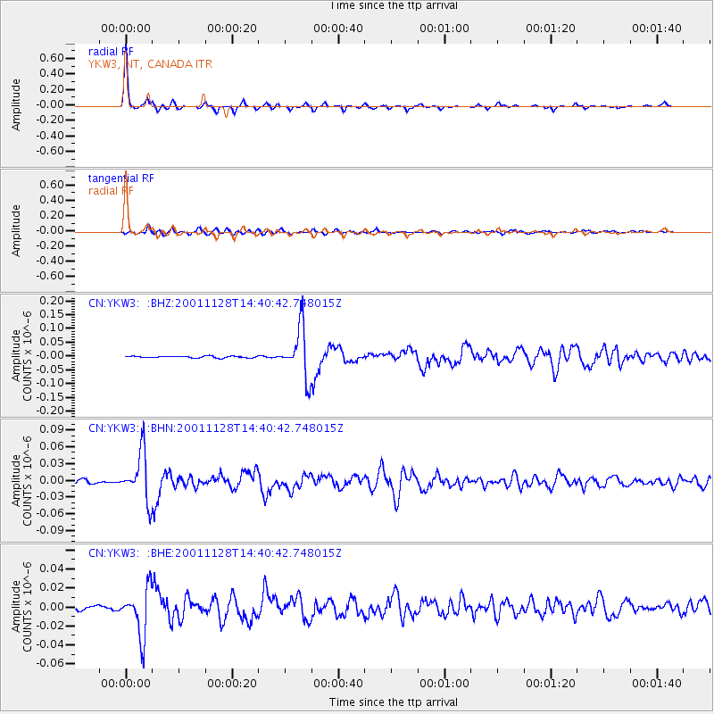
Signal To Noise
| Channel | StoN | STA | LTA |
| CN:YKW3: :BHN:20011128T14:40:42.748015Z | 15.875302 | 4.4158153E-8 | 2.7815628E-9 |
| CN:YKW3: :BHE:20011128T14:40:42.748015Z | 6.4691525 | 2.5501942E-8 | 3.942084E-9 |
| CN:YKW3: :BHZ:20011128T14:40:42.748015Z | 30.94308 | 9.368818E-8 | 3.0277585E-9 |
| Arrivals |
| Ps | 8.9 SECOND |
| PpPs | 27 SECOND |
| PsPs/PpSs | 36 SECOND |


