You are here: Home > Network List > CN - Canadian National Seismograph Network Stations List
> Station YKW3 YKW3, NT, CANADA > Earthquake Result Viewer
YKW3 YKW3, NT, CANADA - Earthquake Result Viewer

| Earthquake location: |
Hokkaido, Japan Region |
| Earthquake latitude/longitude: |
41.0/142.3 |
| Earthquake time(UTC): |
2001/08/13 (225) 20:11:23 GMT |
| Earthquake Depth: |
38 km |
| Earthquake Magnitude: |
6.0 MB, 6.3 MS, 6.4 MW, 6.3 ME |
| Earthquake Catalog/Contributor: |
WHDF/NEIC |
|
| Network: |
CN Canadian National Seismograph Network |
| Station: |
YKW3 YKW3, NT, CANADA |
| Lat/Lon: |
62.56 N/114.61 W |
| Elevation: |
170 m |
|
| Distance: |
60.0 deg |
| Az: |
31.41 deg |
| Baz: |
301.685 deg |
| Ray Param: |
0.061766874 |
| Estimated Moho Depth: |
36.75 km |
| Estimated Crust Vp/Vs: |
1.69 |
| Assumed Crust Vp: |
6.459 km/s |
| Estimated Crust Vs: |
3.817 km/s |
| Estimated Crust Poisson's Ratio: |
0.23 |
|
| Radial Match: |
98.32145 % |
| Radial Bump: |
284 |
| Transverse Match: |
85.891785 % |
| Transverse Bump: |
400 |
| SOD ConfigId: |
20082 |
| Insert Time: |
2010-02-27 08:14:06.881 +0000 |
| GWidth: |
2.5 |
| Max Bumps: |
400 |
| Tol: |
0.001 |
|
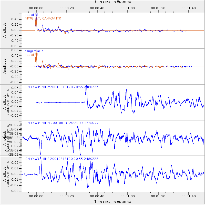
Signal To Noise
| Channel | StoN | STA | LTA |
| CN:YKW3: :BHN:20010813T20:20:55.248022Z | 8.7153015 | 7.066777E-9 | 8.108471E-10 |
| CN:YKW3: :BHE:20010813T20:20:55.248022Z | 16.783075 | 1.1967778E-8 | 7.130861E-10 |
| CN:YKW3: :BHZ:20010813T20:20:55.248022Z | 32.559925 | 2.8569259E-8 | 8.7743623E-10 |
| Arrivals |
| Ps | 4.1 SECOND |
| PpPs | 15 SECOND |
| PsPs/PpSs | 19 SECOND |


