You are here: Home > Network List > CN - Canadian National Seismograph Network Stations List
> Station YKW3 YKW3, NT, CANADA > Earthquake Result Viewer
YKW3 YKW3, NT, CANADA - Earthquake Result Viewer
| Earthquake location: |
Hokkaido, Japan Region |
| Earthquake latitude/longitude: |
43.0/143.8 |
| Earthquake time(UTC): |
1999/05/12 (132) 17:59:22 GMT |
| Earthquake Depth: |
103 km |
| Earthquake Magnitude: |
5.9 MB, 6.2 MW, 6.1 MW |
| Earthquake Catalog/Contributor: |
WHDF/NEIC |
|
| Network: |
CN Canadian National Seismograph Network |
| Station: |
YKW3 YKW3, NT, CANADA |
| Lat/Lon: |
62.56 N/114.61 W |
| Elevation: |
170 m |
|
| Distance: |
57.7 deg |
| Az: |
32.481 deg |
| Baz: |
301.784 deg |
| Ray Param: |
0.06303219 |
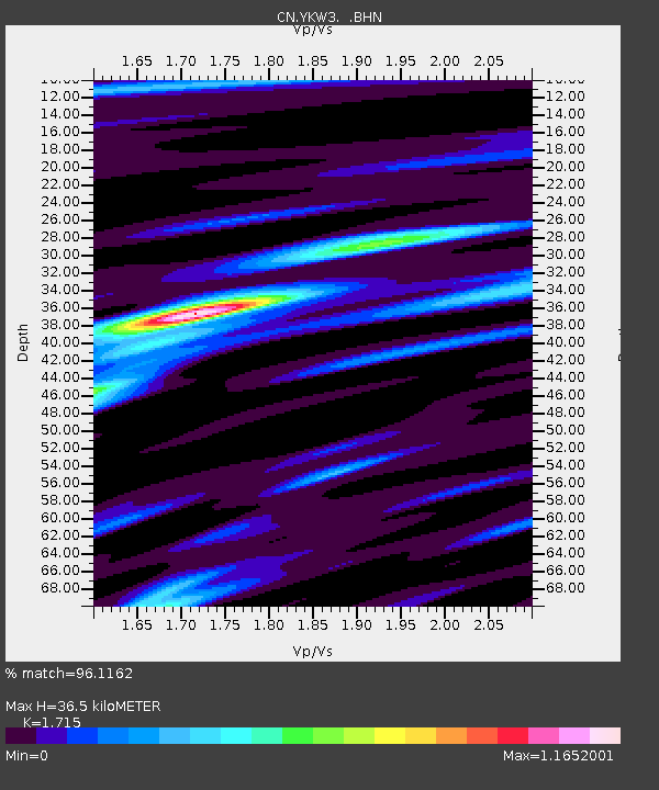
| Estimated Moho Depth: |
36.5 km |
| Estimated Crust Vp/Vs: |
1.72 |
| Assumed Crust Vp: |
6.459 km/s |
| Estimated Crust Vs: |
3.766 km/s |
| Estimated Crust Poisson's Ratio: |
0.24 |
|
| Radial Match: |
96.1162 % |
| Radial Bump: |
287 |
| Transverse Match: |
82.575485 % |
| Transverse Bump: |
400 |
| SOD ConfigId: |
4480 |
| Insert Time: |
2010-02-27 08:14:20.064 +0000 |
| GWidth: |
2.5 |
| Max Bumps: |
400 |
| Tol: |
0.001 |
|
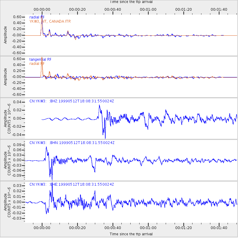
Signal To Noise
| Channel | StoN | STA | LTA |
| CN:YKW3: :BHN:19990512T18:08:31.550024Z | 47.530365 | 3.9521904E-8 | 8.3150853E-10 |
| CN:YKW3: :BHE:19990512T18:08:31.550024Z | 8.617751 | 1.028394E-8 | 1.1933439E-9 |
| CN:YKW3: :BHZ:19990512T18:08:31.550024Z | 9.927155 | 1.6618435E-8 | 1.6740379E-9 |
| Arrivals |
| Ps | 4.3 SECOND |
| PpPs | 15 SECOND |
| PsPs/PpSs | 19 SECOND |


