You are here: Home > Network List > IU - Global Seismograph Network (GSN - IRIS/USGS) Stations List
> Station RSSD Black Hills, South Dakota, USA > Earthquake Result Viewer
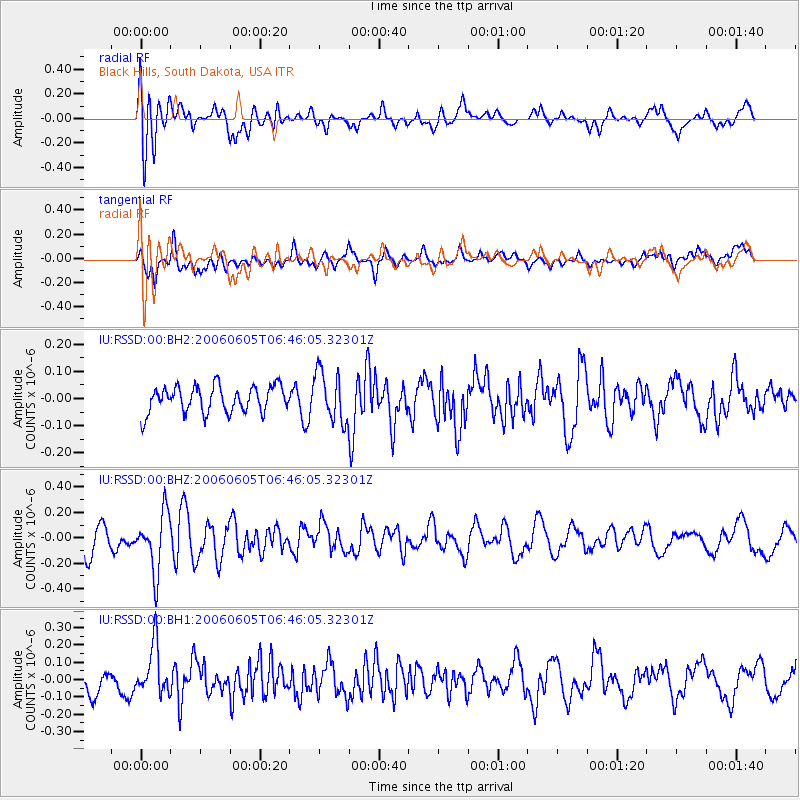
RSSD Black Hills, South Dakota, USA - Earthquake Result Viewer
*The percent match for this event was below the threshold and hence no stack was calculated.
| Earthquake location: |
Central Mid-Atlantic Ridge |
| Earthquake latitude/longitude: |
1.0/-28.2 |
| Earthquake time(UTC): |
2006/06/05 (156) 06:34:31 GMT |
| Earthquake Depth: |
10 km |
| Earthquake Magnitude: |
5.3 MB, 5.6 MW |
| Earthquake Catalog/Contributor: |
WHDF/NEIC |
|
| Network: |
IU Global Seismograph Network (GSN - IRIS/USGS) |
| Station: |
RSSD Black Hills, South Dakota, USA |
| Lat/Lon: |
44.12 N/104.04 W |
| Elevation: |
2060 m |
|
| Distance: |
79.2 deg |
| Az: |
314.675 deg |
| Baz: |
99.173 deg |
| Ray Param: |
$rayparam |
*The percent match for this event was below the threshold and hence was not used in the summary stack. |
|
| Radial Match: |
61.45424 % |
| Radial Bump: |
400 |
| Transverse Match: |
57.79122 % |
| Transverse Bump: |
400 |
| SOD ConfigId: |
590571 |
| Insert Time: |
2013-09-25 22:00:17.025 +0000 |
| GWidth: |
2.5 |
| Max Bumps: |
400 |
| Tol: |
0.001 |
|
Signal To Noise
| Channel | StoN | STA | LTA |
| IU:RSSD:00:BHZ:20060605T06:46:05.32301Z | 2.378576 | 2.3098175E-7 | 9.710925E-8 |
| IU:RSSD:00:BH1:20060605T06:46:05.32301Z | 1.7624263 | 1.4312114E-7 | 8.1206885E-8 |
| IU:RSSD:00:BH2:20060605T06:46:05.32301Z | 1.8685536 | 9.1134034E-8 | 4.87725E-8 |
| Arrivals |
| Ps | |
| PpPs | |
| PsPs/PpSs | |


