You are here: Home > Network List > IU - Global Seismograph Network (GSN - IRIS/USGS) Stations List
> Station RSSD Black Hills, South Dakota, USA > Earthquake Result Viewer
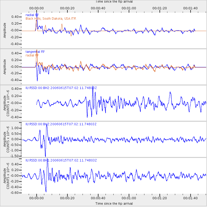
RSSD Black Hills, South Dakota, USA - Earthquake Result Viewer
*The percent match for this event was below the threshold and hence no stack was calculated.
| Earthquake location: |
Mongolia |
| Earthquake latitude/longitude: |
45.4/97.4 |
| Earthquake time(UTC): |
2006/06/15 (166) 06:49:48 GMT |
| Earthquake Depth: |
9.0 km |
| Earthquake Magnitude: |
5.7 MB, 5.6 MS, 5.8 MW, 5.8 MW |
| Earthquake Catalog/Contributor: |
WHDF/NEIC |
|
| Network: |
IU Global Seismograph Network (GSN - IRIS/USGS) |
| Station: |
RSSD Black Hills, South Dakota, USA |
| Lat/Lon: |
44.12 N/104.04 W |
| Elevation: |
2060 m |
|
| Distance: |
88.9 deg |
| Az: |
15.232 deg |
| Baz: |
345.104 deg |
| Ray Param: |
$rayparam |
*The percent match for this event was below the threshold and hence was not used in the summary stack. |
|
| Radial Match: |
66.98632 % |
| Radial Bump: |
400 |
| Transverse Match: |
78.335266 % |
| Transverse Bump: |
400 |
| SOD ConfigId: |
590571 |
| Insert Time: |
2013-09-25 22:12:48.385 +0000 |
| GWidth: |
2.5 |
| Max Bumps: |
400 |
| Tol: |
0.001 |
|
Signal To Noise
| Channel | StoN | STA | LTA |
| IU:RSSD:00:BHZ:20060615T07:02:11.74803Z | 3.7288826 | 4.1736675E-7 | 1.1192811E-7 |
| IU:RSSD:00:BH1:20060615T07:02:11.74803Z | 1.3836915 | 1.3769916E-7 | 9.951579E-8 |
| IU:RSSD:00:BH2:20060615T07:02:11.74803Z | 2.3761175 | 1.2896069E-7 | 5.4273706E-8 |
| Arrivals |
| Ps | |
| PpPs | |
| PsPs/PpSs | |


