You are here: Home > Network List > CN - Canadian National Seismograph Network Stations List
> Station YKW3 > Earthquake Result Viewer
YKW3 - Earthquake Result Viewer
| Earthquake location: |
Near Coast Of Peru |
| Earthquake latitude/longitude: |
-16.1/-74.0 |
| Earthquake time(UTC): |
2001/07/05 (186) 13:53:48 GMT |
| Earthquake Depth: |
62 km |
| Earthquake Magnitude: |
6.2 MB, 6.6 MW, 6.5 ME |
| Earthquake Catalog/Contributor: |
WHDF/NEIC |
|
| Network: |
CN Canadian National Seismograph Network |
| Station: |
YKW3 |
| Lat/Lon: |
62.56 N/114.62 W |
| Elevation: |
200 m |
|
| Distance: |
84.6 deg |
| Az: |
342.363 deg |
| Baz: |
141.041 deg |
| Ray Param: |
0.045242917 |
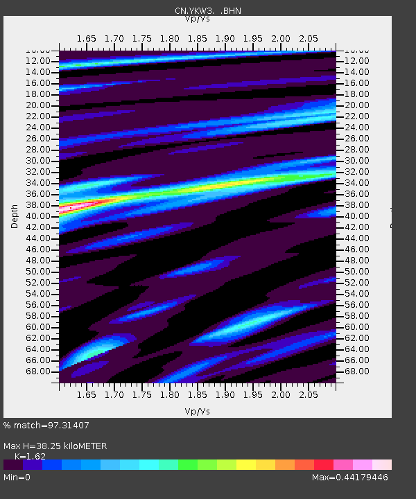
| Estimated Moho Depth: |
38.25 km |
| Estimated Crust Vp/Vs: |
1.62 |
| Assumed Crust Vp: |
6.459 km/s |
| Estimated Crust Vs: |
3.987 km/s |
| Estimated Crust Poisson's Ratio: |
0.19 |
|
| Radial Match: |
97.31407 % |
| Radial Bump: |
296 |
| Transverse Match: |
85.185844 % |
| Transverse Bump: |
400 |
| SOD ConfigId: |
4714 |
| Insert Time: |
2010-02-27 08:14:58.019 +0000 |
| GWidth: |
2.5 |
| Max Bumps: |
400 |
| Tol: |
0.001 |
|

Signal To Noise
| Channel | StoN | STA | LTA |
| CN:YKW3: :BHN:20010705T14:05:43.950027Z | 3.0936058 | 718.3093 | 232.19162 |
| CN:YKW3: :BHE:20010705T14:05:43.950027Z | 3.1947727 | 800.30975 | 250.50601 |
| CN:YKW3: :BHZ:20010705T14:05:43.950027Z | 7.6948757 | 2771.6099 | 360.18903 |
| Arrivals |
| Ps | 3.8 SECOND |
| PpPs | 15 SECOND |
| PsPs/PpSs | 19 SECOND |


