You are here: Home > Network List > TA - USArray Transportable Network (new EarthScope stations) Stations List
> Station R11A Troy Canyon, Currant, NV, USA > Earthquake Result Viewer
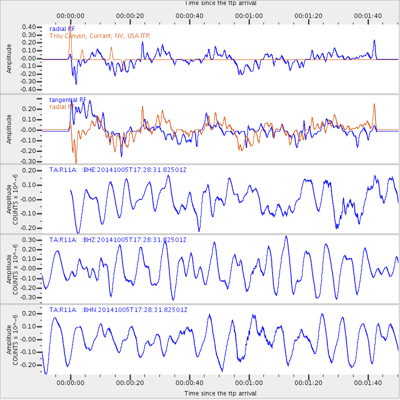
R11A Troy Canyon, Currant, NV, USA - Earthquake Result Viewer
*The percent match for this event was below the threshold and hence no stack was calculated.
| Earthquake location: |
Fiji Islands Region |
| Earthquake latitude/longitude: |
-19.7/-176.1 |
| Earthquake time(UTC): |
2014/10/05 (278) 17:16:48 GMT |
| Earthquake Depth: |
10 km |
| Earthquake Magnitude: |
5.4 MW |
| Earthquake Catalog/Contributor: |
ISC/ISC |
|
| Network: |
TA USArray Transportable Network (new EarthScope stations) |
| Station: |
R11A Troy Canyon, Currant, NV, USA |
| Lat/Lon: |
38.35 N/115.59 W |
| Elevation: |
1756 m |
|
| Distance: |
81.0 deg |
| Az: |
43.897 deg |
| Baz: |
236.193 deg |
| Ray Param: |
$rayparam |
*The percent match for this event was below the threshold and hence was not used in the summary stack. |
|
| Radial Match: |
62.72814 % |
| Radial Bump: |
400 |
| Transverse Match: |
53.29922 % |
| Transverse Bump: |
400 |
| SOD ConfigId: |
3390531 |
| Insert Time: |
2019-04-14 09:01:19.660 +0000 |
| GWidth: |
2.5 |
| Max Bumps: |
400 |
| Tol: |
0.001 |
|
Signal To Noise
| Channel | StoN | STA | LTA |
| TA:R11A: :BHZ:20141005T17:28:31.82501Z | 0.37560079 | 6.231891E-8 | 1.6591794E-7 |
| TA:R11A: :BHN:20141005T17:28:31.82501Z | 0.79861337 | 1.0883612E-7 | 1.3628137E-7 |
| TA:R11A: :BHE:20141005T17:28:31.82501Z | 1.1727197 | 1.0714879E-7 | 9.1367774E-8 |
| Arrivals |
| Ps | |
| PpPs | |
| PsPs/PpSs | |


