You are here: Home > Network List > IU - Global Seismograph Network (GSN - IRIS/USGS) Stations List
> Station RSSD Black Hills, South Dakota, USA > Earthquake Result Viewer
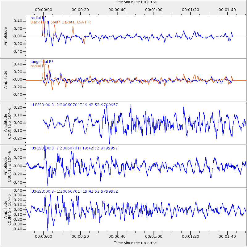
RSSD Black Hills, South Dakota, USA - Earthquake Result Viewer
*The percent match for this event was below the threshold and hence no stack was calculated.
| Earthquake location: |
Andreanof Islands, Aleutian Is. |
| Earthquake latitude/longitude: |
51.1/-179.3 |
| Earthquake time(UTC): |
2006/07/01 (182) 19:34:39 GMT |
| Earthquake Depth: |
42 km |
| Earthquake Magnitude: |
5.2 MB, 5.1 MS, 5.5 MW, 5.3 MW |
| Earthquake Catalog/Contributor: |
WHDF/NEIC |
|
| Network: |
IU Global Seismograph Network (GSN - IRIS/USGS) |
| Station: |
RSSD Black Hills, South Dakota, USA |
| Lat/Lon: |
44.12 N/104.04 W |
| Elevation: |
2060 m |
|
| Distance: |
49.2 deg |
| Az: |
66.992 deg |
| Baz: |
306.248 deg |
| Ray Param: |
$rayparam |
*The percent match for this event was below the threshold and hence was not used in the summary stack. |
|
| Radial Match: |
73.64428 % |
| Radial Bump: |
400 |
| Transverse Match: |
44.278423 % |
| Transverse Bump: |
400 |
| SOD ConfigId: |
590571 |
| Insert Time: |
2013-09-25 22:38:34.757 +0000 |
| GWidth: |
2.5 |
| Max Bumps: |
400 |
| Tol: |
0.001 |
|
Signal To Noise
| Channel | StoN | STA | LTA |
| IU:RSSD:00:BHZ:20060701T19:42:52.979995Z | 4.5483856 | 2.2841391E-7 | 5.0218674E-8 |
| IU:RSSD:00:BH1:20060701T19:42:52.979995Z | 3.1107948 | 1.7646636E-7 | 5.6727096E-8 |
| IU:RSSD:00:BH2:20060701T19:42:52.979995Z | 2.0927033 | 1.1594623E-7 | 5.5405003E-8 |
| Arrivals |
| Ps | |
| PpPs | |
| PsPs/PpSs | |


