You are here: Home > Network List > IU - Global Seismograph Network (GSN - IRIS/USGS) Stations List
> Station RSSD Black Hills, South Dakota, USA > Earthquake Result Viewer
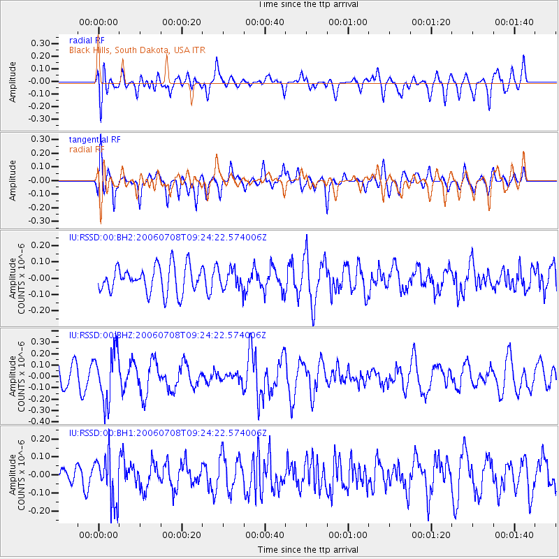
RSSD Black Hills, South Dakota, USA - Earthquake Result Viewer
*The percent match for this event was below the threshold and hence no stack was calculated.
| Earthquake location: |
La Rioja Province, Argentina |
| Earthquake latitude/longitude: |
-28.6/-67.4 |
| Earthquake time(UTC): |
2006/07/08 (189) 09:13:01 GMT |
| Earthquake Depth: |
140 km |
| Earthquake Magnitude: |
5.5 MW |
| Earthquake Catalog/Contributor: |
NEIC PDE/NEIC PDE-M |
|
| Network: |
IU Global Seismograph Network (GSN - IRIS/USGS) |
| Station: |
RSSD Black Hills, South Dakota, USA |
| Lat/Lon: |
44.12 N/104.04 W |
| Elevation: |
2060 m |
|
| Distance: |
79.7 deg |
| Az: |
334.095 deg |
| Baz: |
147.751 deg |
| Ray Param: |
$rayparam |
*The percent match for this event was below the threshold and hence was not used in the summary stack. |
|
| Radial Match: |
55.578865 % |
| Radial Bump: |
400 |
| Transverse Match: |
58.30875 % |
| Transverse Bump: |
400 |
| SOD ConfigId: |
590571 |
| Insert Time: |
2013-09-25 22:53:25.531 +0000 |
| GWidth: |
2.5 |
| Max Bumps: |
400 |
| Tol: |
0.001 |
|
Signal To Noise
| Channel | StoN | STA | LTA |
| IU:RSSD:00:BHZ:20060708T09:24:22.574006Z | 2.907878 | 2.2359615E-7 | 7.689324E-8 |
| IU:RSSD:00:BH1:20060708T09:24:22.574006Z | 1.609022 | 1.2958596E-7 | 8.053709E-8 |
| IU:RSSD:00:BH2:20060708T09:24:22.574006Z | 0.7405253 | 6.0171224E-8 | 8.125479E-8 |
| Arrivals |
| Ps | |
| PpPs | |
| PsPs/PpSs | |


