You are here: Home > Network List > TA - USArray Transportable Network (new EarthScope stations) Stations List
> Station I23K Minto, Yukon-Koyukuk, AK, USA > Earthquake Result Viewer
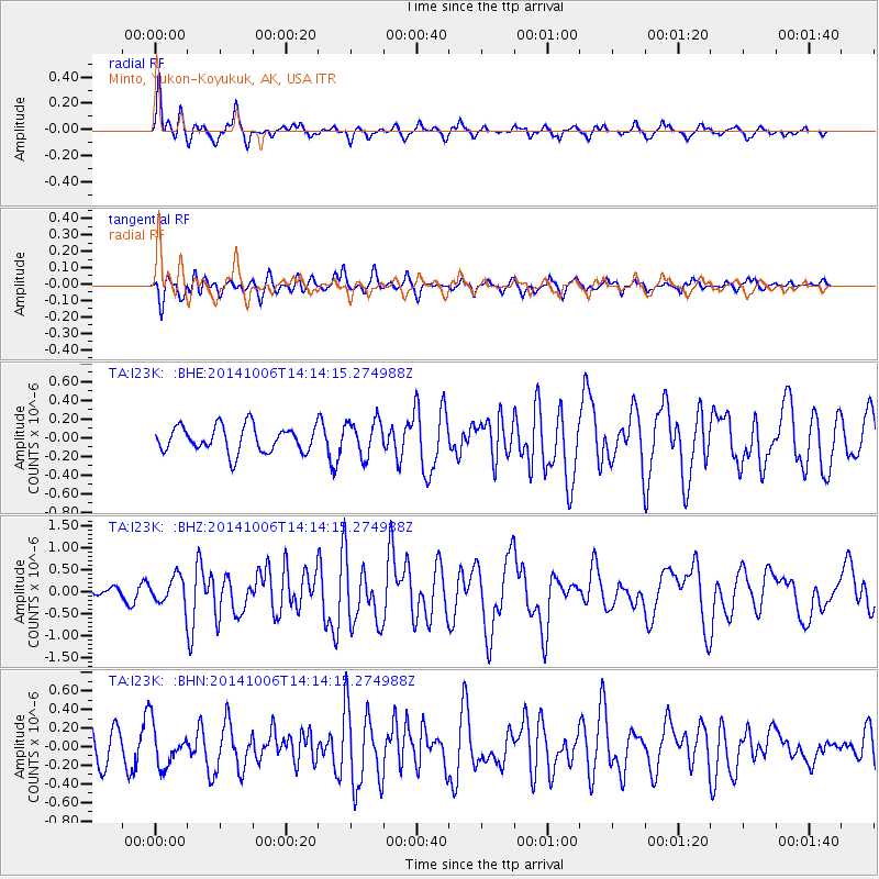
I23K Minto, Yukon-Koyukuk, AK, USA - Earthquake Result Viewer
*The percent match for this event was below the threshold and hence no stack was calculated.
| Earthquake location: |
Mariana Islands Region |
| Earthquake latitude/longitude: |
15.5/147.3 |
| Earthquake time(UTC): |
2014/10/06 (279) 14:04:05 GMT |
| Earthquake Depth: |
6.9 km |
| Earthquake Magnitude: |
5.6 MB |
| Earthquake Catalog/Contributor: |
NEIC PDE/NEIC ALERT |
|
| Network: |
TA USArray Transportable Network (new EarthScope stations) |
| Station: |
I23K Minto, Yukon-Koyukuk, AK, USA |
| Lat/Lon: |
65.15 N/149.36 W |
| Elevation: |
149 m |
|
| Distance: |
65.0 deg |
| Az: |
24.636 deg |
| Baz: |
252.013 deg |
| Ray Param: |
$rayparam |
*The percent match for this event was below the threshold and hence was not used in the summary stack. |
|
| Radial Match: |
78.00788 % |
| Radial Bump: |
392 |
| Transverse Match: |
61.71462 % |
| Transverse Bump: |
400 |
| SOD ConfigId: |
3390531 |
| Insert Time: |
2019-04-14 09:07:59.268 +0000 |
| GWidth: |
2.5 |
| Max Bumps: |
400 |
| Tol: |
0.001 |
|
Signal To Noise
| Channel | StoN | STA | LTA |
| TA:I23K: :BHZ:20141006T14:14:15.274988Z | 3.377353 | 3.2369587E-7 | 9.584307E-8 |
| TA:I23K: :BHN:20141006T14:14:15.274988Z | 0.8677473 | 2.1879869E-7 | 2.5214564E-7 |
| TA:I23K: :BHE:20141006T14:14:15.274988Z | 1.39511 | 1.9098005E-7 | 1.3689247E-7 |
| Arrivals |
| Ps | |
| PpPs | |
| PsPs/PpSs | |


