You are here: Home > Network List > US - United States National Seismic Network Stations List
> Station MNTX Cornudas Mountains, Texas, USA > Earthquake Result Viewer
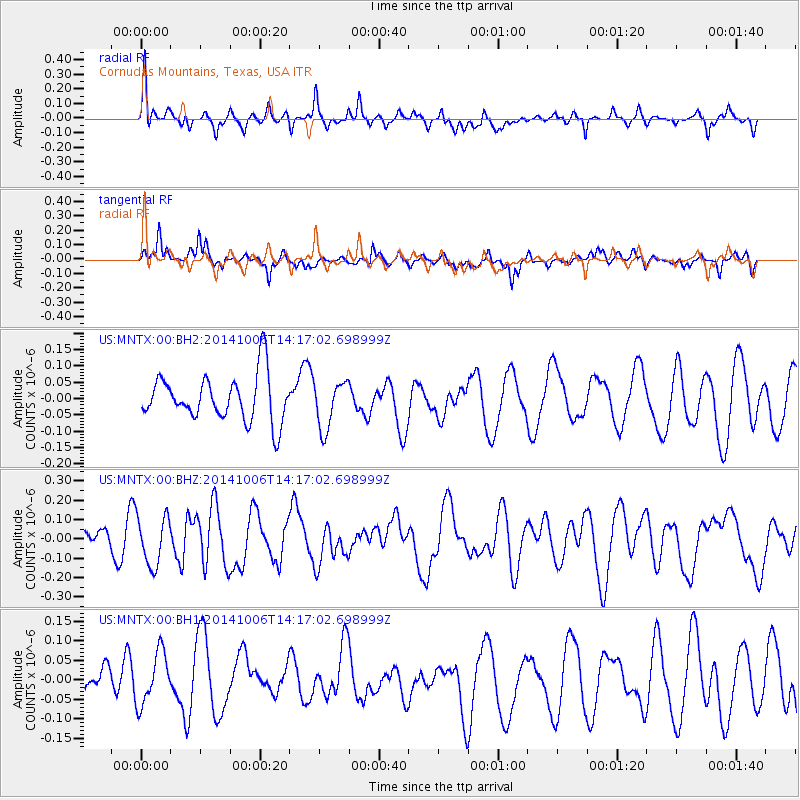
MNTX Cornudas Mountains, Texas, USA - Earthquake Result Viewer
*The percent match for this event was below the threshold and hence no stack was calculated.
| Earthquake location: |
Mariana Islands Region |
| Earthquake latitude/longitude: |
15.5/147.3 |
| Earthquake time(UTC): |
2014/10/06 (279) 14:04:05 GMT |
| Earthquake Depth: |
6.9 km |
| Earthquake Magnitude: |
5.6 MB |
| Earthquake Catalog/Contributor: |
NEIC PDE/NEIC ALERT |
|
| Network: |
US United States National Seismic Network |
| Station: |
MNTX Cornudas Mountains, Texas, USA |
| Lat/Lon: |
31.70 N/105.38 W |
| Elevation: |
404 m |
|
| Distance: |
96.1 deg |
| Az: |
54.915 deg |
| Baz: |
292.227 deg |
| Ray Param: |
$rayparam |
*The percent match for this event was below the threshold and hence was not used in the summary stack. |
|
| Radial Match: |
57.52434 % |
| Radial Bump: |
400 |
| Transverse Match: |
63.677677 % |
| Transverse Bump: |
400 |
| SOD ConfigId: |
3390531 |
| Insert Time: |
2019-04-14 09:08:40.339 +0000 |
| GWidth: |
2.5 |
| Max Bumps: |
400 |
| Tol: |
0.001 |
|
Signal To Noise
| Channel | StoN | STA | LTA |
| US:MNTX:00:BHZ:20141006T14:17:02.698999Z | 1.7094789 | 1.2527269E-7 | 7.3281214E-8 |
| US:MNTX:00:BH1:20141006T14:17:02.698999Z | 1.192505 | 7.092853E-8 | 5.9478598E-8 |
| US:MNTX:00:BH2:20141006T14:17:02.698999Z | 1.0634822 | 7.594425E-8 | 7.141093E-8 |
| Arrivals |
| Ps | |
| PpPs | |
| PsPs/PpSs | |


