You are here: Home > Network List > IU - Global Seismograph Network (GSN - IRIS/USGS) Stations List
> Station TATO Taipei, Taiwan > Earthquake Result Viewer
TATO Taipei, Taiwan - Earthquake Result Viewer
| Earthquake location: |
South Of Java, Indonesia |
| Earthquake latitude/longitude: |
-9.3/107.4 |
| Earthquake time(UTC): |
2006/07/17 (198) 08:19:28 GMT |
| Earthquake Depth: |
34 km |
| Earthquake Magnitude: |
6.1 MB, 7.2 MS, 7.7 MW, 7.2 MW |
| Earthquake Catalog/Contributor: |
WHDF/NEIC |
|
| Network: |
IU Global Seismograph Network (GSN - IRIS/USGS) |
| Station: |
TATO Taipei, Taiwan |
| Lat/Lon: |
24.98 N/121.49 E |
| Elevation: |
53 m |
|
| Distance: |
36.7 deg |
| Az: |
21.684 deg |
| Baz: |
203.697 deg |
| Ray Param: |
0.07648151 |
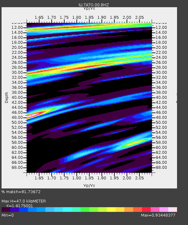
| Estimated Moho Depth: |
47.0 km |
| Estimated Crust Vp/Vs: |
1.62 |
| Assumed Crust Vp: |
6.289 km/s |
| Estimated Crust Vs: |
3.888 km/s |
| Estimated Crust Poisson's Ratio: |
0.19 |
|
| Radial Match: |
91.73672 % |
| Radial Bump: |
400 |
| Transverse Match: |
68.83182 % |
| Transverse Bump: |
400 |
| SOD ConfigId: |
590571 |
| Insert Time: |
2013-09-25 23:06:58.109 +0000 |
| GWidth: |
2.5 |
| Max Bumps: |
400 |
| Tol: |
0.001 |
|

Signal To Noise
| Channel | StoN | STA | LTA |
| IU:TATO:00:BHZ:20060717T08:26:01.64801Z | 4.6103377 | 3.941139E-6 | 8.548482E-7 |
| IU:TATO:00:BH1:20060717T08:26:01.64801Z | 2.1907296 | 1.9146328E-6 | 8.7397035E-7 |
| IU:TATO:00:BH2:20060717T08:26:01.64801Z | 2.8194697 | 2.361087E-6 | 8.3742236E-7 |
| Arrivals |
| Ps | 5.0 SECOND |
| PpPs | 18 SECOND |
| PsPs/PpSs | 23 SECOND |


