You are here: Home > Network List > IU - Global Seismograph Network (GSN - IRIS/USGS) Stations List
> Station RSSD Black Hills, South Dakota, USA > Earthquake Result Viewer
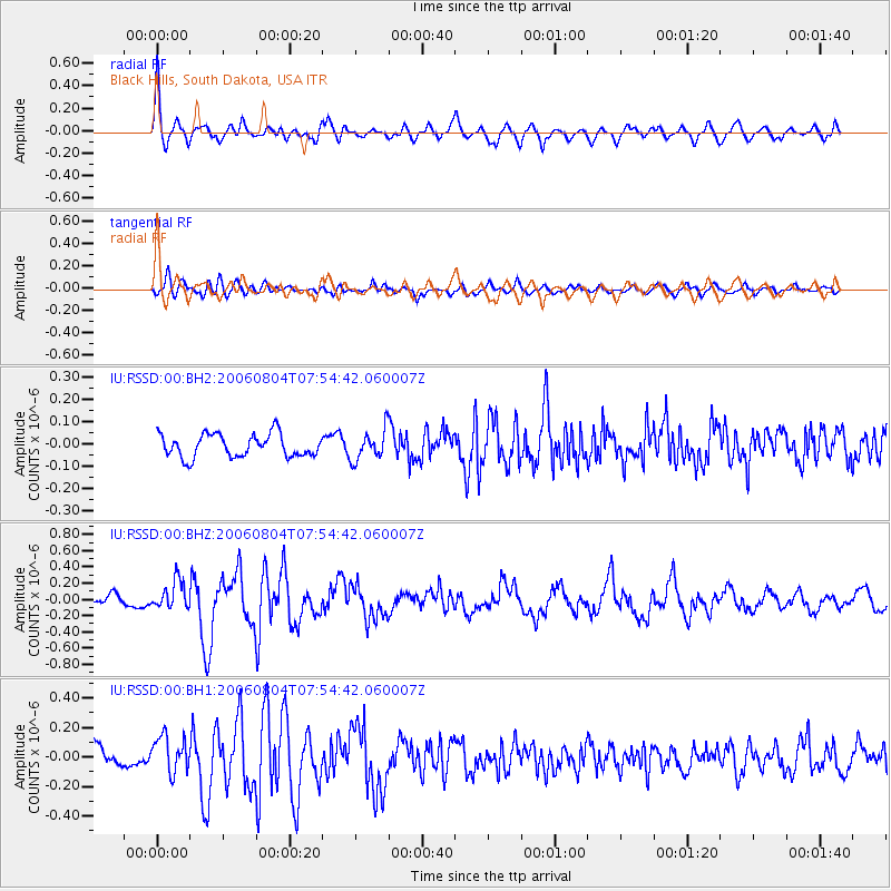
RSSD Black Hills, South Dakota, USA - Earthquake Result Viewer
*The percent match for this event was below the threshold and hence no stack was calculated.
| Earthquake location: |
Near Islands, Aleutian Islands |
| Earthquake latitude/longitude: |
52.1/171.0 |
| Earthquake time(UTC): |
2006/08/04 (216) 07:45:47 GMT |
| Earthquake Depth: |
10 km |
| Earthquake Magnitude: |
5.4 MB, 4.9 MS, 5.5 MW, 5.5 MW |
| Earthquake Catalog/Contributor: |
WHDF/NEIC |
|
| Network: |
IU Global Seismograph Network (GSN - IRIS/USGS) |
| Station: |
RSSD Black Hills, South Dakota, USA |
| Lat/Lon: |
44.12 N/104.04 W |
| Elevation: |
2060 m |
|
| Distance: |
54.2 deg |
| Az: |
62.238 deg |
| Baz: |
310.752 deg |
| Ray Param: |
$rayparam |
*The percent match for this event was below the threshold and hence was not used in the summary stack. |
|
| Radial Match: |
75.37144 % |
| Radial Bump: |
400 |
| Transverse Match: |
61.838486 % |
| Transverse Bump: |
400 |
| SOD ConfigId: |
590571 |
| Insert Time: |
2013-09-25 23:51:42.313 +0000 |
| GWidth: |
2.5 |
| Max Bumps: |
400 |
| Tol: |
0.001 |
|
Signal To Noise
| Channel | StoN | STA | LTA |
| IU:RSSD:00:BHZ:20060804T07:54:42.060007Z | 2.148733 | 1.7493461E-7 | 8.1412914E-8 |
| IU:RSSD:00:BH1:20060804T07:54:42.060007Z | 1.2455213 | 1.2521456E-7 | 1.0053184E-7 |
| IU:RSSD:00:BH2:20060804T07:54:42.060007Z | 1.3082157 | 6.7659954E-8 | 5.1719258E-8 |
| Arrivals |
| Ps | |
| PpPs | |
| PsPs/PpSs | |


