You are here: Home > Network List > IU - Global Seismograph Network (GSN - IRIS/USGS) Stations List
> Station RSSD Black Hills, South Dakota, USA > Earthquake Result Viewer
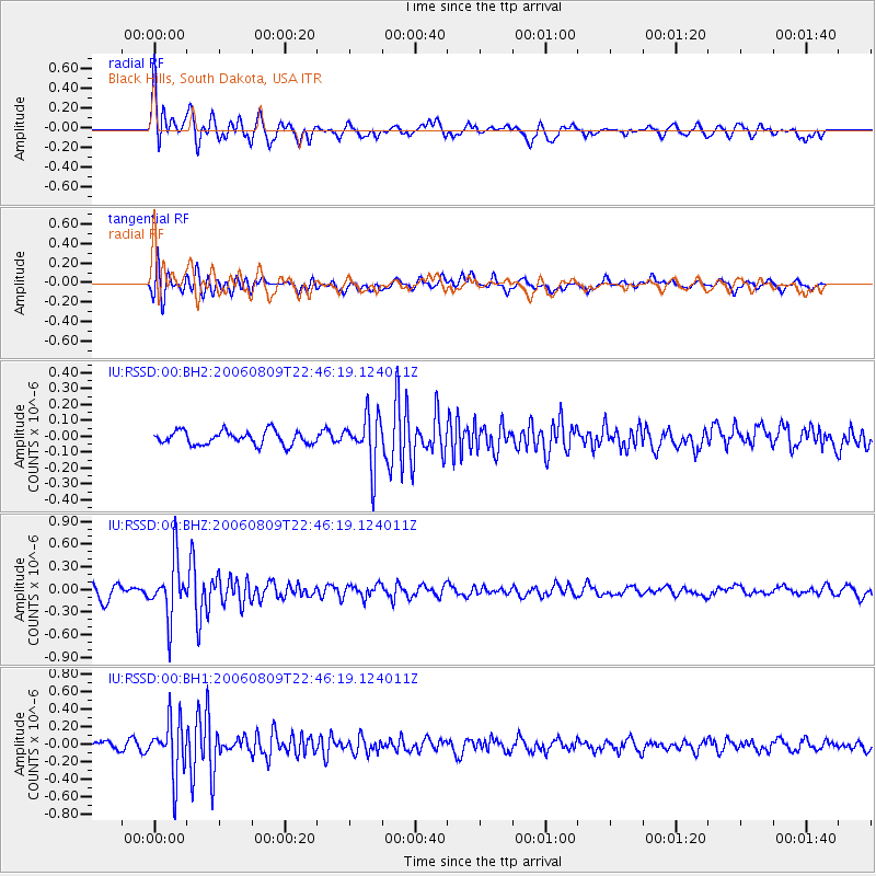
RSSD Black Hills, South Dakota, USA - Earthquake Result Viewer
*The percent match for this event was below the threshold and hence no stack was calculated.
| Earthquake location: |
Central Peru |
| Earthquake latitude/longitude: |
-14.4/-70.7 |
| Earthquake time(UTC): |
2006/08/09 (221) 22:36:08 GMT |
| Earthquake Depth: |
29 km |
| Earthquake Magnitude: |
5.6 MB, 4.6 MS, 5.2 MW, 5.2 ML |
| Earthquake Catalog/Contributor: |
WHDF/NEIC |
|
| Network: |
IU Global Seismograph Network (GSN - IRIS/USGS) |
| Station: |
RSSD Black Hills, South Dakota, USA |
| Lat/Lon: |
44.12 N/104.04 W |
| Elevation: |
2060 m |
|
| Distance: |
65.7 deg |
| Az: |
334.291 deg |
| Baz: |
144.298 deg |
| Ray Param: |
$rayparam |
*The percent match for this event was below the threshold and hence was not used in the summary stack. |
|
| Radial Match: |
74.449905 % |
| Radial Bump: |
400 |
| Transverse Match: |
78.15348 % |
| Transverse Bump: |
400 |
| SOD ConfigId: |
590571 |
| Insert Time: |
2013-09-26 00:01:32.238 +0000 |
| GWidth: |
2.5 |
| Max Bumps: |
400 |
| Tol: |
0.001 |
|
Signal To Noise
| Channel | StoN | STA | LTA |
| IU:RSSD:00:BHZ:20060809T22:46:19.124011Z | 4.6700726 | 3.8050376E-7 | 8.1477054E-8 |
| IU:RSSD:00:BH1:20060809T22:46:19.124011Z | 5.184541 | 3.1397704E-7 | 6.056024E-8 |
| IU:RSSD:00:BH2:20060809T22:46:19.124011Z | 3.699445 | 1.5902637E-7 | 4.298655E-8 |
| Arrivals |
| Ps | |
| PpPs | |
| PsPs/PpSs | |


