You are here: Home > Network List > IU - Global Seismograph Network (GSN - IRIS/USGS) Stations List
> Station RSSD Black Hills, South Dakota, USA > Earthquake Result Viewer
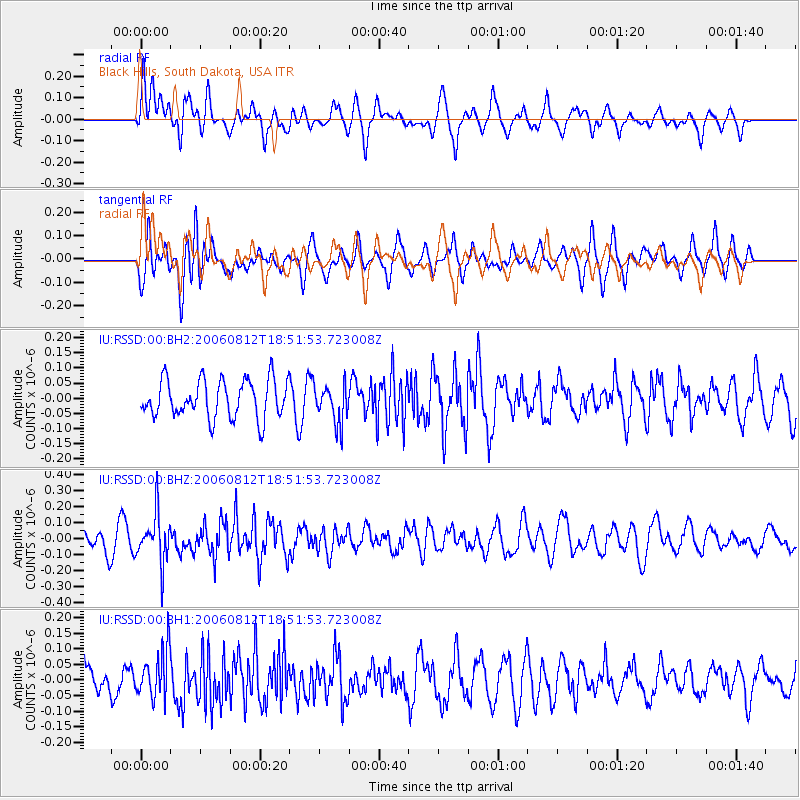
RSSD Black Hills, South Dakota, USA - Earthquake Result Viewer
*The percent match for this event was below the threshold and hence no stack was calculated.
| Earthquake location: |
Ryukyu Islands, Japan |
| Earthquake latitude/longitude: |
28.8/130.0 |
| Earthquake time(UTC): |
2006/08/12 (224) 18:39:18 GMT |
| Earthquake Depth: |
28 km |
| Earthquake Magnitude: |
5.6 MB, 5.0 MS, 5.5 MW, 5.4 MW |
| Earthquake Catalog/Contributor: |
WHDF/NEIC |
|
| Network: |
IU Global Seismograph Network (GSN - IRIS/USGS) |
| Station: |
RSSD Black Hills, South Dakota, USA |
| Lat/Lon: |
44.12 N/104.04 W |
| Elevation: |
2060 m |
|
| Distance: |
92.2 deg |
| Az: |
35.694 deg |
| Baz: |
314.678 deg |
| Ray Param: |
$rayparam |
*The percent match for this event was below the threshold and hence was not used in the summary stack. |
|
| Radial Match: |
57.906185 % |
| Radial Bump: |
400 |
| Transverse Match: |
51.677197 % |
| Transverse Bump: |
400 |
| SOD ConfigId: |
590571 |
| Insert Time: |
2013-09-26 00:05:01.012 +0000 |
| GWidth: |
2.5 |
| Max Bumps: |
400 |
| Tol: |
0.001 |
|
Signal To Noise
| Channel | StoN | STA | LTA |
| IU:RSSD:00:BHZ:20060812T18:51:53.723008Z | 2.9695535 | 1.5042245E-7 | 5.0654908E-8 |
| IU:RSSD:00:BH1:20060812T18:51:53.723008Z | 1.754058 | 7.7450224E-8 | 4.415488E-8 |
| IU:RSSD:00:BH2:20060812T18:51:53.723008Z | 0.9946945 | 6.2386135E-8 | 6.271889E-8 |
| Arrivals |
| Ps | |
| PpPs | |
| PsPs/PpSs | |


