You are here: Home > Network List > IU - Global Seismograph Network (GSN - IRIS/USGS) Stations List
> Station RSSD Black Hills, South Dakota, USA > Earthquake Result Viewer
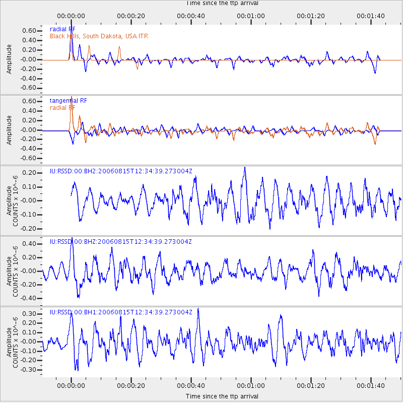
RSSD Black Hills, South Dakota, USA - Earthquake Result Viewer
*The percent match for this event was below the threshold and hence no stack was calculated.
| Earthquake location: |
Rat Islands, Aleutian Islands |
| Earthquake latitude/longitude: |
51.1/179.3 |
| Earthquake time(UTC): |
2006/08/15 (227) 12:26:17 GMT |
| Earthquake Depth: |
20 km |
| Earthquake Magnitude: |
5.5 MW, 5.7 MW |
| Earthquake Catalog/Contributor: |
NEIC PDE/NEIC PDE-M |
|
| Network: |
IU Global Seismograph Network (GSN - IRIS/USGS) |
| Station: |
RSSD Black Hills, South Dakota, USA |
| Lat/Lon: |
44.12 N/104.04 W |
| Elevation: |
2060 m |
|
| Distance: |
50.0 deg |
| Az: |
66.213 deg |
| Baz: |
306.752 deg |
| Ray Param: |
$rayparam |
*The percent match for this event was below the threshold and hence was not used in the summary stack. |
|
| Radial Match: |
60.991474 % |
| Radial Bump: |
345 |
| Transverse Match: |
59.631542 % |
| Transverse Bump: |
400 |
| SOD ConfigId: |
590571 |
| Insert Time: |
2013-09-26 00:13:40.955 +0000 |
| GWidth: |
2.5 |
| Max Bumps: |
400 |
| Tol: |
0.001 |
|
Signal To Noise
| Channel | StoN | STA | LTA |
| IU:RSSD:00:BHZ:20060815T12:34:39.273004Z | 2.7364213 | 2.4886333E-7 | 9.0944816E-8 |
| IU:RSSD:00:BH1:20060815T12:34:39.273004Z | 2.152162 | 1.7859844E-7 | 8.2985586E-8 |
| IU:RSSD:00:BH2:20060815T12:34:39.273004Z | 0.8001628 | 4.7742105E-8 | 5.9665496E-8 |
| Arrivals |
| Ps | |
| PpPs | |
| PsPs/PpSs | |


