You are here: Home > Network List > IU - Global Seismograph Network (GSN - IRIS/USGS) Stations List
> Station RSSD Black Hills, South Dakota, USA > Earthquake Result Viewer
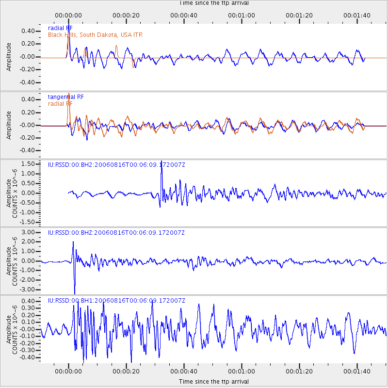
RSSD Black Hills, South Dakota, USA - Earthquake Result Viewer
*The percent match for this event was below the threshold and hence no stack was calculated.
| Earthquake location: |
Fiji Islands Region |
| Earthquake latitude/longitude: |
-21.2/-176.3 |
| Earthquake time(UTC): |
2006/08/15 (227) 23:53:47 GMT |
| Earthquake Depth: |
158 km |
| Earthquake Magnitude: |
5.9 MB, 6.1 MW, 6.1 MW |
| Earthquake Catalog/Contributor: |
WHDF/NEIC |
|
| Network: |
IU Global Seismograph Network (GSN - IRIS/USGS) |
| Station: |
RSSD Black Hills, South Dakota, USA |
| Lat/Lon: |
44.12 N/104.04 W |
| Elevation: |
2060 m |
|
| Distance: |
92.5 deg |
| Az: |
43.351 deg |
| Baz: |
242.809 deg |
| Ray Param: |
$rayparam |
*The percent match for this event was below the threshold and hence was not used in the summary stack. |
|
| Radial Match: |
77.844604 % |
| Radial Bump: |
400 |
| Transverse Match: |
73.04429 % |
| Transverse Bump: |
400 |
| SOD ConfigId: |
590571 |
| Insert Time: |
2013-09-26 00:15:18.685 +0000 |
| GWidth: |
2.5 |
| Max Bumps: |
400 |
| Tol: |
0.001 |
|
Signal To Noise
| Channel | StoN | STA | LTA |
| IU:RSSD:00:BHZ:20060816T00:06:09.172007Z | 10.156109 | 9.713593E-7 | 9.564287E-8 |
| IU:RSSD:00:BH1:20060816T00:06:09.172007Z | 1.9168252 | 1.7418463E-7 | 9.0871424E-8 |
| IU:RSSD:00:BH2:20060816T00:06:09.172007Z | 5.247704 | 4.5547205E-7 | 8.6794536E-8 |
| Arrivals |
| Ps | |
| PpPs | |
| PsPs/PpSs | |


