You are here: Home > Network List > CN - Canadian National Seismograph Network Stations List
> Station YKW3 YKW3, NT, CANADA > Earthquake Result Viewer
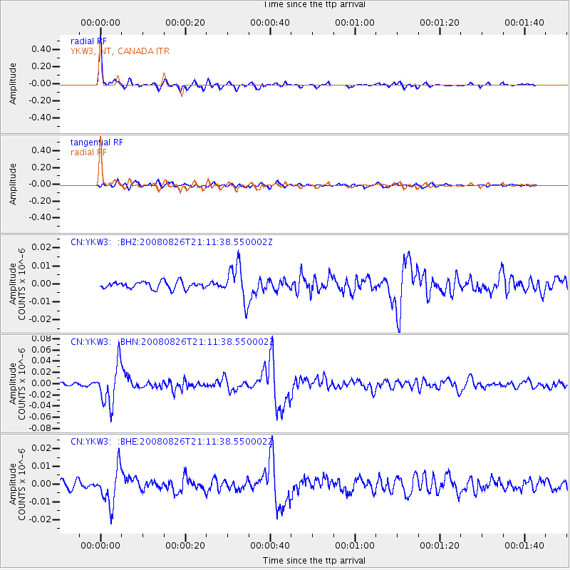
YKW3 YKW3, NT, CANADA - Earthquake Result Viewer

| Earthquake location: |
Peru-Brazil Border Region |
| Earthquake latitude/longitude: |
-7.6/-74.4 |
| Earthquake time(UTC): |
2008/08/26 (239) 21:00:36 GMT |
| Earthquake Depth: |
154 km |
| Earthquake Magnitude: |
6.0 MB, 6.4 MW, 6.4 MW |
| Earthquake Catalog/Contributor: |
WHDF/NEIC |
|
| Network: |
CN Canadian National Seismograph Network |
| Station: |
YKW3 YKW3, NT, CANADA |
| Lat/Lon: |
62.56 N/114.61 W |
| Elevation: |
170 m |
|
| Distance: |
76.5 deg |
| Az: |
342.079 deg |
| Baz: |
138.819 deg |
| Ray Param: |
0.05057255 |
| Estimated Moho Depth: |
63.75 km |
| Estimated Crust Vp/Vs: |
1.66 |
| Assumed Crust Vp: |
6.459 km/s |
| Estimated Crust Vs: |
3.88 km/s |
| Estimated Crust Poisson's Ratio: |
0.22 |
|
| Radial Match: |
94.72665 % |
| Radial Bump: |
248 |
| Transverse Match: |
73.679756 % |
| Transverse Bump: |
400 |
| SOD ConfigId: |
2504 |
| Insert Time: |
2010-02-27 08:19:14.304 +0000 |
| GWidth: |
2.5 |
| Max Bumps: |
400 |
| Tol: |
0.001 |
|
Signal To Noise
| Channel | StoN | STA | LTA |
| CN:YKW3: :BHN:20080826T21:11:38.550002Z | 18.979994 | 3.6775905E-8 | 1.9376143E-9 |
| CN:YKW3: :BHE:20080826T21:11:38.550002Z | 6.2685175 | 1.0654154E-8 | 1.699629E-9 |
| CN:YKW3: :BHZ:20080826T21:11:38.550002Z | 5.215716 | 1.0235254E-8 | 1.9623874E-9 |
| Arrivals |
| Ps | 6.8 SECOND |
| PpPs | 25 SECOND |
| PsPs/PpSs | 32 SECOND |


