You are here: Home > Network List > IU - Global Seismograph Network (GSN - IRIS/USGS) Stations List
> Station RSSD Black Hills, South Dakota, USA > Earthquake Result Viewer
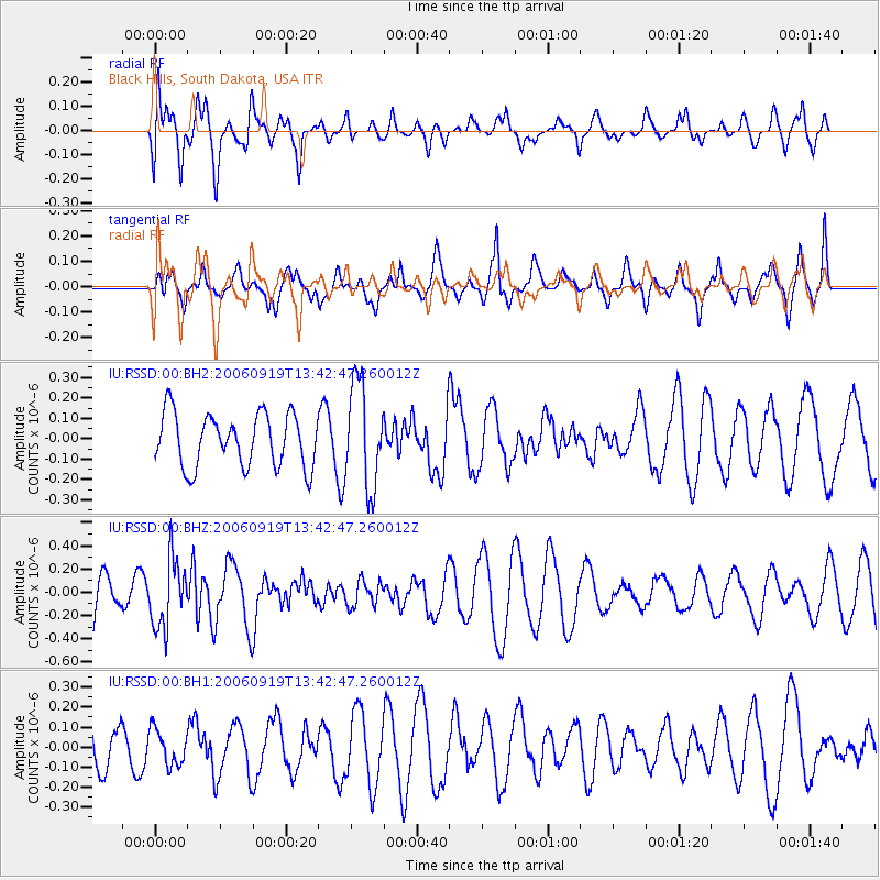
RSSD Black Hills, South Dakota, USA - Earthquake Result Viewer
*The percent match for this event was below the threshold and hence no stack was calculated.
| Earthquake location: |
South Of Tonga Islands |
| Earthquake latitude/longitude: |
-26.2/-175.6 |
| Earthquake time(UTC): |
2006/09/19 (262) 13:29:54 GMT |
| Earthquake Depth: |
18 km |
| Earthquake Magnitude: |
5.7 MB, 5.4 MS, 5.7 MW, 5.6 MW |
| Earthquake Catalog/Contributor: |
WHDF/NEIC |
|
| Network: |
IU Global Seismograph Network (GSN - IRIS/USGS) |
| Station: |
RSSD Black Hills, South Dakota, USA |
| Lat/Lon: |
44.12 N/104.04 W |
| Elevation: |
2060 m |
|
| Distance: |
95.7 deg |
| Az: |
43.366 deg |
| Baz: |
238.974 deg |
| Ray Param: |
$rayparam |
*The percent match for this event was below the threshold and hence was not used in the summary stack. |
|
| Radial Match: |
73.48382 % |
| Radial Bump: |
400 |
| Transverse Match: |
51.071186 % |
| Transverse Bump: |
400 |
| SOD ConfigId: |
590571 |
| Insert Time: |
2013-09-26 01:15:08.730 +0000 |
| GWidth: |
2.5 |
| Max Bumps: |
400 |
| Tol: |
0.001 |
|
Signal To Noise
| Channel | StoN | STA | LTA |
| IU:RSSD:00:BHZ:20060919T13:42:47.260012Z | 1.4281594 | 2.940716E-7 | 2.0590952E-7 |
| IU:RSSD:00:BH1:20060919T13:42:47.260012Z | 0.5388149 | 8.830805E-8 | 1.6389312E-7 |
| IU:RSSD:00:BH2:20060919T13:42:47.260012Z | 1.9697696 | 2.5556187E-7 | 1.29742E-7 |
| Arrivals |
| Ps | |
| PpPs | |
| PsPs/PpSs | |


