You are here: Home > Network List > IU - Global Seismograph Network (GSN - IRIS/USGS) Stations List
> Station RSSD Black Hills, South Dakota, USA > Earthquake Result Viewer
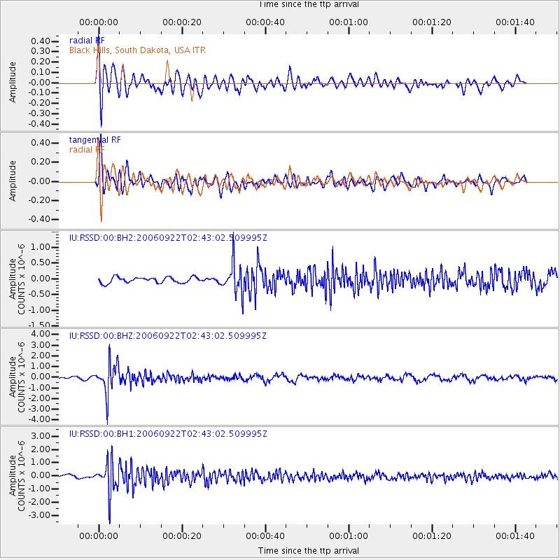
RSSD Black Hills, South Dakota, USA - Earthquake Result Viewer
*The percent match for this event was below the threshold and hence no stack was calculated.
| Earthquake location: |
Santiago Del Estero Prov., Arg. |
| Earthquake latitude/longitude: |
-26.9/-63.1 |
| Earthquake time(UTC): |
2006/09/22 (265) 02:32:25 GMT |
| Earthquake Depth: |
598 km |
| Earthquake Magnitude: |
6.1 MB, 6.0 MW, 6.0 MW |
| Earthquake Catalog/Contributor: |
WHDF/NEIC |
|
| Network: |
IU Global Seismograph Network (GSN - IRIS/USGS) |
| Station: |
RSSD Black Hills, South Dakota, USA |
| Lat/Lon: |
44.12 N/104.04 W |
| Elevation: |
2060 m |
|
| Distance: |
80.0 deg |
| Az: |
331.395 deg |
| Baz: |
143.571 deg |
| Ray Param: |
$rayparam |
*The percent match for this event was below the threshold and hence was not used in the summary stack. |
|
| Radial Match: |
65.91017 % |
| Radial Bump: |
400 |
| Transverse Match: |
67.06759 % |
| Transverse Bump: |
400 |
| SOD ConfigId: |
590571 |
| Insert Time: |
2013-09-26 01:19:17.491 +0000 |
| GWidth: |
2.5 |
| Max Bumps: |
400 |
| Tol: |
0.001 |
|
Signal To Noise
| Channel | StoN | STA | LTA |
| IU:RSSD:00:BHZ:20060922T02:43:02.509995Z | 15.111555 | 1.4226707E-6 | 9.414456E-8 |
| IU:RSSD:00:BH1:20060922T02:43:02.509995Z | 10.562938 | 1.1386545E-6 | 1.0779714E-7 |
| IU:RSSD:00:BH2:20060922T02:43:02.509995Z | 5.097264 | 4.632157E-7 | 9.087537E-8 |
| Arrivals |
| Ps | |
| PpPs | |
| PsPs/PpSs | |


