You are here: Home > Network List > IU - Global Seismograph Network (GSN - IRIS/USGS) Stations List
> Station RSSD Black Hills, South Dakota, USA > Earthquake Result Viewer
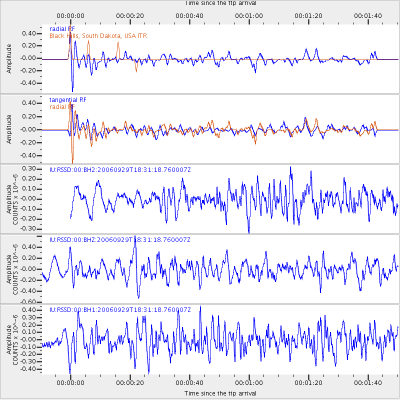
RSSD Black Hills, South Dakota, USA - Earthquake Result Viewer
*The percent match for this event was below the threshold and hence no stack was calculated.
| Earthquake location: |
Trinidad |
| Earthquake latitude/longitude: |
10.8/-61.8 |
| Earthquake time(UTC): |
2006/09/29 (272) 18:23:05 GMT |
| Earthquake Depth: |
52 km |
| Earthquake Magnitude: |
5.3 MB, 4.8 MS, 5.5 MW, 5.5 MW |
| Earthquake Catalog/Contributor: |
WHDF/NEIC |
|
| Network: |
IU Global Seismograph Network (GSN - IRIS/USGS) |
| Station: |
RSSD Black Hills, South Dakota, USA |
| Lat/Lon: |
44.12 N/104.04 W |
| Elevation: |
2060 m |
|
| Distance: |
49.2 deg |
| Az: |
320.236 deg |
| Baz: |
119.244 deg |
| Ray Param: |
$rayparam |
*The percent match for this event was below the threshold and hence was not used in the summary stack. |
|
| Radial Match: |
59.928467 % |
| Radial Bump: |
400 |
| Transverse Match: |
53.083286 % |
| Transverse Bump: |
400 |
| SOD ConfigId: |
590571 |
| Insert Time: |
2013-09-26 01:31:24.929 +0000 |
| GWidth: |
2.5 |
| Max Bumps: |
400 |
| Tol: |
0.001 |
|
Signal To Noise
| Channel | StoN | STA | LTA |
| IU:RSSD:00:BHZ:20060929T18:31:18.760007Z | 1.0953206 | 1.7366028E-7 | 1.5854745E-7 |
| IU:RSSD:00:BH1:20060929T18:31:18.760007Z | 1.9734465 | 2.2501897E-7 | 1.14023344E-7 |
| IU:RSSD:00:BH2:20060929T18:31:18.760007Z | 1.1226056 | 9.554237E-8 | 8.510769E-8 |
| Arrivals |
| Ps | |
| PpPs | |
| PsPs/PpSs | |


