You are here: Home > Network List > ER - Mount Erebus Volcano Observatory Seismic Network Stations List
> Station HOO Hoopers Shoulder,Mt Erebus Volcano Observatory Network, > Earthquake Result Viewer
HOO Hoopers Shoulder,Mt Erebus Volcano Observatory Network, - Earthquake Result Viewer
| Earthquake location: |
Southeast Indian Ridge |
| Earthquake latitude/longitude: |
-45.7/96.0 |
| Earthquake time(UTC): |
2006/10/22 (295) 08:55:16 GMT |
| Earthquake Depth: |
10 km |
| Earthquake Magnitude: |
6.1 MW, 5.6 MB, 6.0 MW, 6.0 MS |
| Earthquake Catalog/Contributor: |
NEIC PDE/NEIC PDE-M |
|
| Network: |
ER Mount Erebus Volcano Observatory Seismic Network |
| Station: |
HOO Hoopers Shoulder,Mt Erebus Volcano Observatory Network, |
| Lat/Lon: |
77.53 S/166.93 E |
| Elevation: |
2069 m |
|
| Distance: |
41.7 deg |
| Az: |
162.027 deg |
| Baz: |
275.876 deg |
| Ray Param: |
0.07360866 |
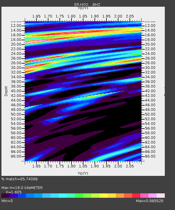
| Estimated Moho Depth: |
19.0 km |
| Estimated Crust Vp/Vs: |
1.61 |
| Assumed Crust Vp: |
6.183 km/s |
| Estimated Crust Vs: |
3.852 km/s |
| Estimated Crust Poisson's Ratio: |
0.18 |
|
| Radial Match: |
85.74086 % |
| Radial Bump: |
400 |
| Transverse Match: |
57.5199 % |
| Transverse Bump: |
400 |
| SOD ConfigId: |
590571 |
| Insert Time: |
2013-09-26 02:23:49.336 +0000 |
| GWidth: |
2.5 |
| Max Bumps: |
400 |
| Tol: |
0.001 |
|

Signal To Noise
| Channel | StoN | STA | LTA |
| ER:HOO: :BHZ:20061022T09:02:34.950002Z | 10.533021 | 2.690456E-6 | 2.5543062E-7 |
| ER:HOO: :BH1:20061022T09:02:34.950002Z | 7.886455 | 1.1464523E-6 | 1.4536978E-7 |
| ER:HOO: :BH2:20061022T09:02:34.950002Z | 1.7114533 | 4.3942495E-7 | 2.5675544E-7 |
| Arrivals |
| Ps | 2.0 SECOND |
| PpPs | 7.5 SECOND |
| PsPs/PpSs | 9.5 SECOND |


