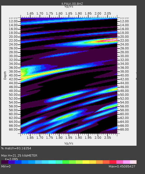
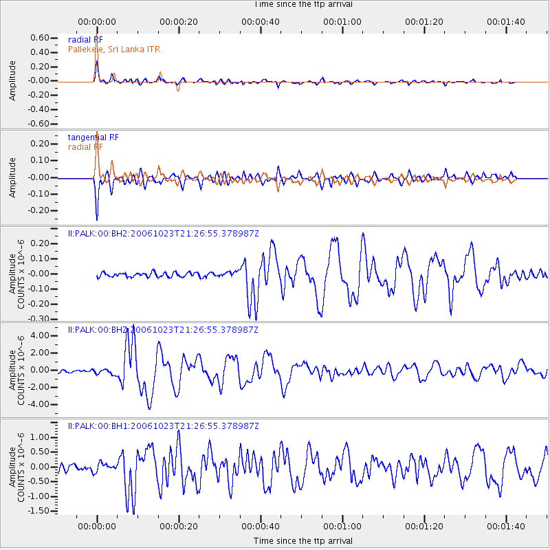
PALK Pallekele, Sri Lanka - Earthquake Result Viewer

Earthquake location: Southeast Of Honshu, Japan
Earthquake latitude/longitude: 29.4/140.3
Earthquake time(UTC): 2006/10/23 (296) 21:17:19 GMT
Earthquake Depth: 11 km
Earthquake Magnitude: 6.4 MW, 6.1 MB, 6.2 MS, 6.4 MW
Earthquake Catalog/Contributor: NEIC PDE/NEIC PDE-M
Network: II Global Seismograph Network (GSN - IRIS/IDA)
Station: PALK Pallekele, Sri Lanka
Lat/Lon: 7.27 N/80.70 E
Elevation: 460 m
Distance: 60.0 deg
Az: 261.015 deg
Baz: 60.368 deg
Ray Param: 0.06181898
Estimated Moho Depth: 21.25 km
Estimated Crust Vp/Vs: 2.10
Assumed Crust Vp: 6.545 km/s
Estimated Crust Vs: 3.124 km/s
Estimated Crust Poisson's Ratio: 0.35
Radial Match: 93.16354 %
Radial Bump: 400
Transverse Match: 89.62057 %
Transverse Bump: 400
SOD ConfigId: 590571
Insert Time: 2013-09-26 02:27:33.955 +0000
GWidth: 2.5
Max Bumps: 400
Tol: 0.001

Signal To Noise

ChannelStoNSTALTA
II:PALK:00:BHZ:20061023T21:26:55.378987Z2.33207963.1269886E-71.3408585E-7
II:PALK:00:BH1:20061023T21:26:55.378987Z1.20914651.4351743E-71.18693166E-7
II:PALK:00:BH2:20061023T21:26:55.378987Z1.18088391.6429736E-81.3913083E-8
Arrivals
Ps3.7 SECOND
PpPs9.6 SECOND
PsPs/PpSs13 SECOND