You are here: Home > Network List > CN - Canadian National Seismograph Network Stations List
> Station YKW3 > Earthquake Result Viewer
YKW3 - Earthquake Result Viewer

| Earthquake location: |
South Of Fiji Islands |
| Earthquake latitude/longitude: |
-22.1/-176.8 |
| Earthquake time(UTC): |
1997/10/14 (287) 09:53:18 GMT |
| Earthquake Depth: |
167 km |
| Earthquake Magnitude: |
6.7 MB, 7.7 UNKNOWN, 7.4 ME |
| Earthquake Catalog/Contributor: |
WHDF/NEIC |
|
| Network: |
CN Canadian National Seismograph Network |
| Station: |
YKW3 |
| Lat/Lon: |
62.56 N/114.62 W |
| Elevation: |
200 m |
|
| Distance: |
97.5 deg |
| Az: |
24.404 deg |
| Baz: |
235.806 deg |
| Ray Param: |
0.04004177 |
| Estimated Moho Depth: |
30.5 km |
| Estimated Crust Vp/Vs: |
2.10 |
| Assumed Crust Vp: |
6.459 km/s |
| Estimated Crust Vs: |
3.08 km/s |
| Estimated Crust Poisson's Ratio: |
0.35 |
|
| Radial Match: |
95.22804 % |
| Radial Bump: |
294 |
| Transverse Match: |
80.39632 % |
| Transverse Bump: |
400 |
| SOD ConfigId: |
6273 |
| Insert Time: |
2010-02-27 08:21:59.532 +0000 |
| GWidth: |
2.5 |
| Max Bumps: |
400 |
| Tol: |
0.001 |
|
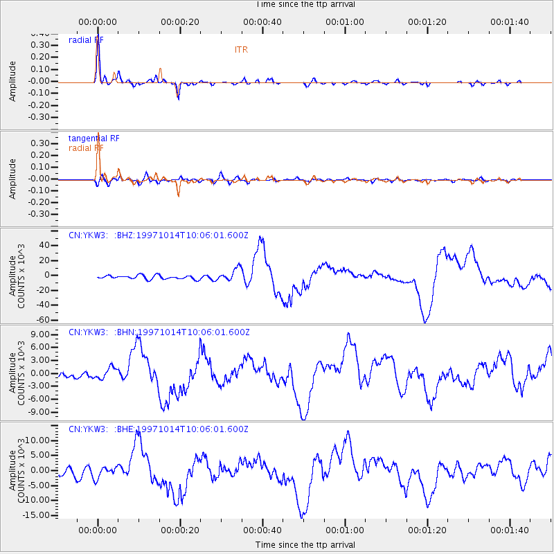
Signal To Noise
| Channel | StoN | STA | LTA |
| CN:YKW3: :BHN:19971014T10:06:01.600Z | 2.7765486 | 1360.0264 | 489.8262 |
| CN:YKW3: :BHE:19971014T10:06:01.600Z | 1.3195757 | 1870.9106 | 1417.8123 |
| CN:YKW3: :BHZ:19971014T10:06:01.600Z | 3.4497614 | 8633.149 | 2502.5352 |
| Arrivals |
| Ps | 5.3 SECOND |
| PpPs | 14 SECOND |
| PsPs/PpSs | 20 SECOND |


