You are here: Home > Network List > IU - Global Seismograph Network (GSN - IRIS/USGS) Stations List
> Station RSSD Black Hills, South Dakota, USA > Earthquake Result Viewer
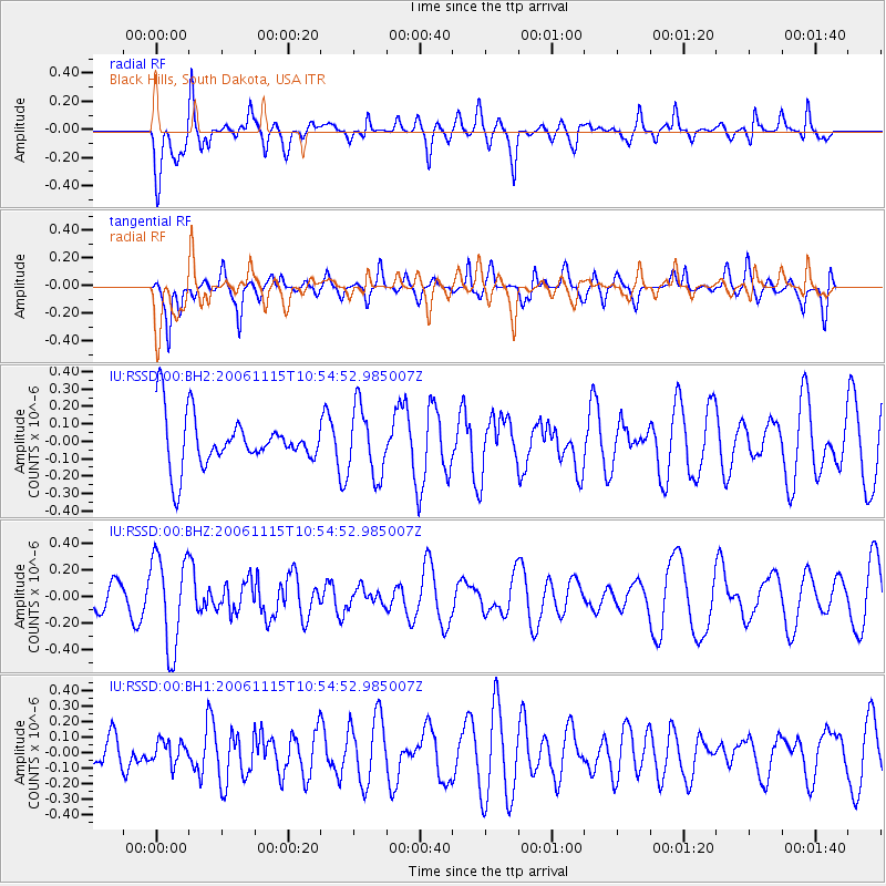
RSSD Black Hills, South Dakota, USA - Earthquake Result Viewer
*The percent match for this event was below the threshold and hence no stack was calculated.
| Earthquake location: |
Easter Island Region |
| Earthquake latitude/longitude: |
-25.1/-112.2 |
| Earthquake time(UTC): |
2006/11/15 (319) 10:44:17 GMT |
| Earthquake Depth: |
10 km |
| Earthquake Magnitude: |
5.5 MW |
| Earthquake Catalog/Contributor: |
NEIC PDE/NEIC PDE-M |
|
| Network: |
IU Global Seismograph Network (GSN - IRIS/USGS) |
| Station: |
RSSD Black Hills, South Dakota, USA |
| Lat/Lon: |
44.12 N/104.04 W |
| Elevation: |
2060 m |
|
| Distance: |
69.3 deg |
| Az: |
6.248 deg |
| Baz: |
187.875 deg |
| Ray Param: |
$rayparam |
*The percent match for this event was below the threshold and hence was not used in the summary stack. |
|
| Radial Match: |
59.65643 % |
| Radial Bump: |
400 |
| Transverse Match: |
52.141964 % |
| Transverse Bump: |
400 |
| SOD ConfigId: |
590571 |
| Insert Time: |
2013-09-26 03:00:38.416 +0000 |
| GWidth: |
2.5 |
| Max Bumps: |
400 |
| Tol: |
0.001 |
|
Signal To Noise
| Channel | StoN | STA | LTA |
| IU:RSSD:00:BHZ:20061115T10:54:52.985007Z | 2.2824903 | 3.4962235E-7 | 1.5317583E-7 |
| IU:RSSD:00:BH1:20061115T10:54:52.985007Z | 0.4899094 | 7.34334E-8 | 1.4989179E-7 |
| IU:RSSD:00:BH2:20061115T10:54:52.985007Z | 1.3316654 | 1.965816E-7 | 1.4762087E-7 |
| Arrivals |
| Ps | |
| PpPs | |
| PsPs/PpSs | |


