You are here: Home > Network List > II - Global Seismograph Network (GSN - IRIS/IDA) Stations List
> Station PALK Pallekele, Sri Lanka > Earthquake Result Viewer
PALK Pallekele, Sri Lanka - Earthquake Result Viewer
| Earthquake location: |
Kuril Islands |
| Earthquake latitude/longitude: |
46.6/153.3 |
| Earthquake time(UTC): |
2006/11/15 (319) 11:14:13 GMT |
| Earthquake Depth: |
10 km |
| Earthquake Magnitude: |
6.5 MB, 7.8 MS, 8.3 MW, 7.9 MW |
| Earthquake Catalog/Contributor: |
WHDF/NEIC |
|
| Network: |
II Global Seismograph Network (GSN - IRIS/IDA) |
| Station: |
PALK Pallekele, Sri Lanka |
| Lat/Lon: |
7.27 N/80.70 E |
| Elevation: |
460 m |
|
| Distance: |
72.8 deg |
| Az: |
262.266 deg |
| Baz: |
43.537 deg |
| Ray Param: |
0.053437058 |
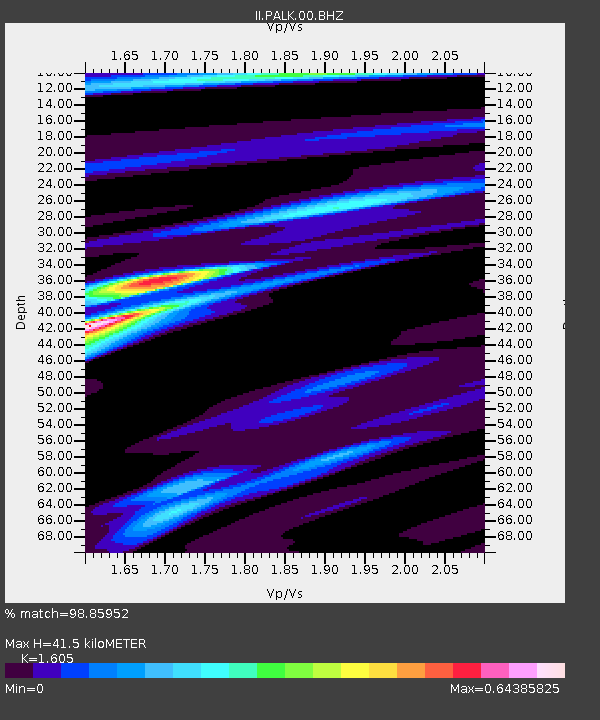
| Estimated Moho Depth: |
41.5 km |
| Estimated Crust Vp/Vs: |
1.61 |
| Assumed Crust Vp: |
6.545 km/s |
| Estimated Crust Vs: |
4.078 km/s |
| Estimated Crust Poisson's Ratio: |
0.18 |
|
| Radial Match: |
98.85952 % |
| Radial Bump: |
174 |
| Transverse Match: |
98.38856 % |
| Transverse Bump: |
251 |
| SOD ConfigId: |
590571 |
| Insert Time: |
2013-09-26 03:01:59.465 +0000 |
| GWidth: |
2.5 |
| Max Bumps: |
400 |
| Tol: |
0.001 |
|
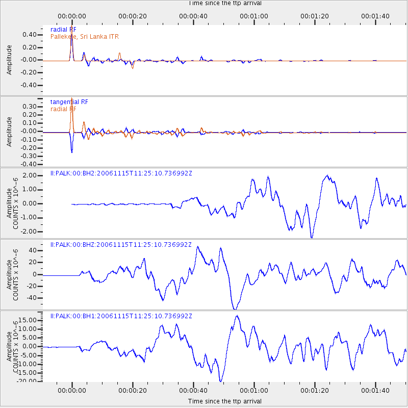
Signal To Noise
| Channel | StoN | STA | LTA |
| II:PALK:00:BHZ:20061115T11:25:10.736992Z | 13.84169 | 2.8080951E-6 | 2.0287227E-7 |
| II:PALK:00:BH1:20061115T11:25:10.736992Z | 6.55896 | 9.775779E-7 | 1.4904465E-7 |
| II:PALK:00:BH2:20061115T11:25:10.736992Z | 4.5054607 | 1.16334014E-7 | 2.5820668E-8 |
| Arrivals |
| Ps | 4.0 SECOND |
| PpPs | 16 SECOND |
| PsPs/PpSs | 20 SECOND |


